
Archive

UNITAR and Esri Host Annual Conference in Geneva
Renowned Speakers Explore Use of Location-Based Tools to Support Sustainable Development Goals Earlier this week, the United Nations Institute for Training and Research (UNITAR) andEsri announced the featured speakers at
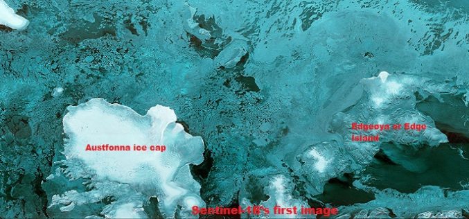
The First Images of Sentinel-1B
Launched on 25 April from Europe’s Spaceport in French Guiana, Sentinel-1B has produced its first images only two hours after the radar was switched on – a record time for

DigitalGlobe to Provide WorldView-4 Access to a New International Defense & Intelligence Customer
WESTMINSTER, Colo.–(BUSINESS WIRE)–Apr. 27, 2016– DigitalGlobe, Inc. (NYSE: DGI), the global leader in earth imagery and information about our changing planet, today announced it has entered into a letter of

Railway Land Management Module to Tackle Encroachment Menace
Railways have developed a web-based application called Land Management Module to provide the status of rail land whether encroached or not which would be helpful in tackling the menace of
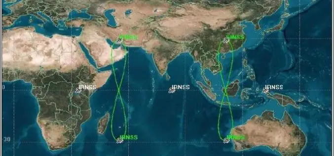
PSLV-C33 Successfully Launches India’s Seventh Navigation Satellite IRNSS-1G
Apr 28, 2016 – In its thirty-fifth flight (PSLV-C33), ISRO’s Polar Satellite Launch Vehicle successfully launched the 1425 kg IRNSS-1G, the seventh satellite in the Indian Regional Navigation Satellite System (IRNSS)
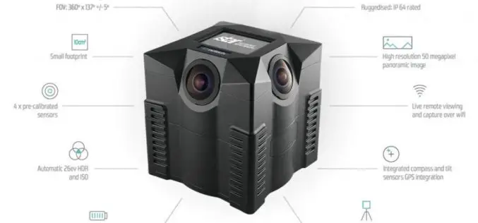
NCTech and Top Gear USA Capture the Rubicon Trail in 360 degrees
iSTAR camera used to create immersive visual experience of challenging off-road route on Google Maps Los Angeles, CA & Edinburgh, UK – April 27, 2016 – NCTech, the developer of

Launch of Nationwide Emergency Response System
April 26, 2016 – New Delhi- The “Nationwide Emergency Response System” project that seeks to establish a modern emergency response system by connecting police with the citizens. It includes integrating
The Power of Maps
The map is a powerful way to visualize data and tell stories. As the internet becomes more and more popular, it is a lot easier to share your maps than

Sentinel-1B – Second Eye of the Earth Guardian in Orbit
Dual launch for European environmental satellite and MicroSCOPE small satellite mission Two eyes are better than one; this principle is also true for the two radar satellites that make up

SimActive Achieves Breakthrough with Latest Correlator3D Release
SimActive Inc., a world-leading developer of photogrammetry software, is pleased to announce the latest version of Correlator3D™, including a completely redesigned aerial triangulation (AT) module. The tie point extraction and
