TatukGIS Releases SDK for ASP.NET Core
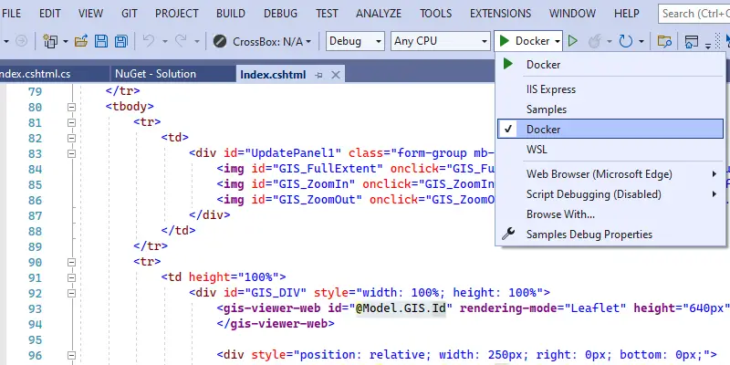
TatukGIS has released the ASP.NET Core edition of its GIS Developer Kernel (DK) product for developing custom web GIS applications for Windows, Linux, and macOS servers (including Docker). Support includes application development using MVC and Razor Pages.
The Developer Kernel for ASP.NET Core edition introduces a vastly expanded JavaScript API with added support for drawing, editing, basic styling, tracking layers, and REST services. HTML user control utilities can access the Leaflet JavaScript library to expose further functionality such as smooth tiles to automatically project locally hosted maps to the coordinate system of a tile server. The SDK can publish REST/WFS/WMS/Tile services.
The new ASP.NET Core support is available to all DK ASP.NET license customers with maintenance support plan. A trial version is available for evaluators.
TatukGIS offers a method to help port existing DK developed Web Forms applications to ASP.NET Core. Similarity of API and geospatial functionality between the DK ASP.NET Core and other DK editions (for other development platforms) means application logic can also be easily reused between desktop and web applications.
Deploying a developed web GIS application to a production server, including cloud services like Amazon AWS or Microsoft Azure, is a simple ‘copy file’ deployment.
The TatukGIS Developer Kernel is a comprehensive GIS SDK available as multiple product editions, each edition compiled natively for a particular development platform: Delphi, .NET, ASP.NET, ActiveX, and Java. Learn more at www.tatukgis.com.
Also Read-
TatukGIS Announces Kernal 11 of its GIS Developer Kernel (DK) for ASP.NET Web Forms