New Scanning and Imaging Solution from Trimble Simplifies 3D Deliverables

Integrated Field and Office Environment Makes Scanning Easier to Transform Data into Decisions
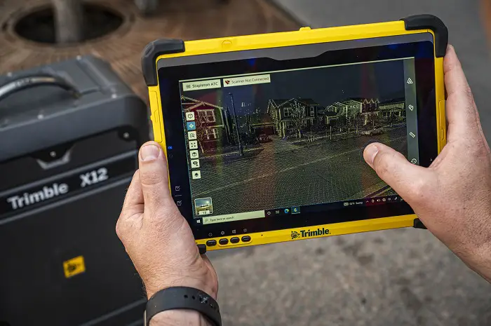
Trimble (NASDAQ: TRMB) has introduced the new Trimble® X12 scanning system to the geospatial scanning portfolio. The X12 integrates intuitive Trimble software for precise data capture and in-field registration with state-of-the-art 3D laser scanning and imaging hardware technology from Zoller+Fröhlich (Z+F), combining the expertise of two industry leaders into a single solution.
The Trimble X12 can be operated by using Trimble Perspective field software installed on a Trimble T10x tablet to enable registration and refinement of scans in the field, ensuring project accuracy and completion before leaving the job site. Users can also leverage Trimble’s customized on-board software menu to configure and operate the scanner. Data is exported from the field and processed in the office with Trimble RealWorks™ software or third-party software. Final deliverables can be shared online with clients and stakeholders using Trimble Clarity, a browser-based data collaboration and visualization tool.

Transforming high-quality 3D data into decisions, such as using scans, models and imagery to determine the structural integrity of aging infrastructure, is streamlined with the Trimble X12 because the data can reside within the Trimble software ecosystem. This advantage allows users to easily visualize, manage and evaluate the project throughout the entire workflow, even for beginners and new users to scanning technology.
With features including best-in-class range (from 0.3 up to 365 meters) and scan speed of up to 2.187 million points per second, the Trimble X12 produces scan data and images with a quality and clarity never seen before—which complements the Trimble X7 capabilities within the scanning product portfolio.

“The Trimble X12 puts the most advanced 3D scan and image capture within reach for a variety of skill levels,” said Jacek Pietruczanis, business area director for Scanning and Mobile Mapping, Trimble Geospatial. “The system enables advanced scanning professionals to improve their productivity with top-of-the-line performance and efficiency gains, while those new to scanning can easily unlock this advanced capability with the touch of a button.”
Availability
The Trimble X12 is available now through Trimble Geospatial’s Authorized Distribution Network. For more information visit: geospatial.trimble.com/X12.
About Trimble Geospatial
Trimble Geospatial provides solutions that facilitate high-quality, productive workflows and information exchange, driving value for a global and diverse customer base of surveyors, engineering and GIS service companies, governments, utilities and transportation authorities. Trimble’s innovative technologies include integrated sensors, field applications, real-time communications and office software for processing, modeling and data analytics. Using Trimble solutions, organizations can capture the most accurate spatial data and transform it into intelligence to deliver increased productivity and improved decision-making. Whether enabling more efficient use of natural resources or enhancing the performance and lifecycle of civil infrastructure, timely and reliable geospatial information is at the core of Trimble’s solutions to transform the way work is done. For more information, visit: geospatial.trimble.com.
About Trimble
Trimble (NASDAQ:TRMB) is an industrial technology company transforming the way the world works by delivering solutions that enable our customers to thrive. Core technologies in positioning, modeling, connectivity and data analytics connect the digital and physical worlds to improve productivity, quality, safety, transparency and sustainability. From purpose-built products to enterprise lifecycle solutions, Trimble is transforming industries such as agriculture, construction, geospatial and transportation. For more information about Trimble, visit: www.trimble.
Also Read –
Trimble Introduces Next Generation High-Accuracy Mapping Solution for GIS Field Applications