Trivim – A Free and Open Source Software for 3D Street Model Generation
 Trivim (Alpha) is a free and open source software for 3D Street Model Generation. Trivim is developed by Indian Institute of Remote Sensing (IIRS). Indian Institute of Remote Sensing (IIRS) under Indian Space Research Organisation, Department of Space, Govt. of India is a premier Training and Educational Institute set up for developing trained professionals in the field of Remote Sensing, Geoinformatics and GPS Technology for Natural Resources, Environmental and Disaster Management.
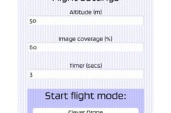
The application can generate 3D street scenarios using a set of 2D images based on the principles of Close Range Photogrammetry. The photos have to be captured with an overlap (minimum being 60%) using consumer grade camera/mobile phone camera along with GPS coordinates of exposure station. Individual floor/residential or commercial unit can be tagged with user defined database.
The application comprises of various processes which generates a 3D model that can be imported to a geoportal (Bhuvan, Google Earth etc.). Also, Database related query can be performed on the model.
Key features:
- One stop solution for generating 3D street views
- On sight Camera Calibration
- Estimation of field time and number of photos
- No on scene GPS point requirement for Geotagging
- Images collected using wide range of cameras/mobile phones can be processed
- Semi automatic segmentation of features
- 3D database creation and simple query options
For more information:
Contact through mail at trivim@iirs.gov.in