Vegetation plays an important role in urban environments from many prospects, i.e., alleviating urban heat island effect, maintaining ecological balance, protecting biodiversity and promoting quality of life. Urban vegetation mapping can be defined as the identification of land cover types over urban vegetated areas according to many studies. It is highly necessary to produce these detailed vegetation maps to assist planners in designing strategies for the optimization of urban ecosystem services and climate change adaptation.
Unmanned aerial vehicle (UAV) remote sensing has great potential for urban vegetation mapping in complex urban landscapes due to the ultra-high resolution imagery acquired at low altitudes. Because of payload capacity restrictions, off-the-shelf digital cameras are widely used on medium and small sized UAVs. The limitation of low spectral resolution in digital cameras for vegetation mapping can be reduced by incorporating texture features and robust classifiers. Random Forest has been widely used in satellite remote sensing applications, but its usage in UAV image classification has not been well documented.
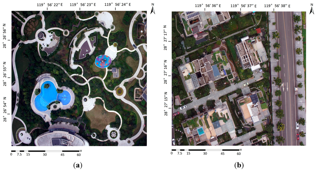
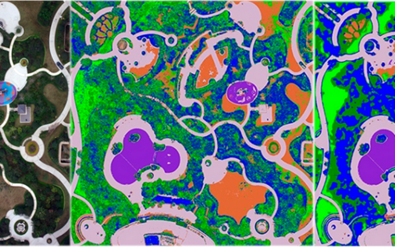
A highly-vegetated recreational park; (b) A complex residential area.
The study propose a hybrid method using Random Forest and texture analysis to accurately differentiate land covers of urban vegetated areas, and analyze how classification accuracy changes with texture window size.
Given the advantage of acquiring VHR and UHR images, UAV provides an easy and cost-efficient approach for urban vegetation monitoring. UHR resolution imagery provides finer images which can capture abundant details of ground objects to assist for very accurate urban vegetation mapping. The study mainly focused on forest mapping, rangeland monitoring and riparian vegetation extraction, etc.
The overall objective of this study is to develop an accurate classification method for urban vegetation mapping via utilizing Random Forest and texture analysis based on UHR digital UAV imagery (7 cm).
Methodology:
The imagery was acquired with a mini-UAV called River-Map. The flight altitude was 200 m resulting in a resolution of 7 cm per-pixel. Raw images taken by the camera were orthorectified then mosaicked into a single image using Pix4D with a root mean square error of 0.2 pixel.
Two small images (1700 × 1700 pixels, about 120 m × 120 m) representing typical urban landscapes were chosen as test data. The images were taken in Lishui, a fast developing city in southwestern Zhejiang Province of China. Besides, the images were collected in October 2013 during the leaf-on conditions and they were provided for Lishui Urban Planning Bureau.
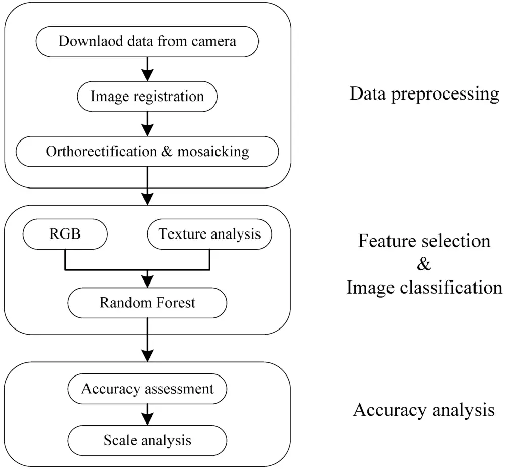
Workflow of urban vegetation mapping using Unmanned Aerial Vehicle (UAV) imagery.
According to field survey and the aim of the project, three vegetated land covers were chosen as follows: grass, trees and shrubs.
Texture Analysis was used and was of second-order (co-occurrence) textures derived from gray-level co-occurrence matrix (GLCM) which indicates the probability that values of each pair of pixels co-occur in a given direction and at certain lag distance in the image.
The definition of land cover classes strictly depends on the aim of the project, the study area and the resolution of the input data. The selection of training samples is very important in the supervised classification methods. Different collection strategies are available such as single pixel selection, seeding and polygon-block selection. Training samples of different land covers were randomly chosen in a small polygon block. It was assumed that all pixels within each polygon belong to the same category. A total of 500 pixels were selected for each land cover class, which was enough to ensure sufficient observations.
Given the input data described in the previous sections, urban vegetation mapping is specified as a supervised classification of UAV orthophotos and ancillary texture features as inputs. In this study, Random Forest was used for image classification because of its robustness and efficiency.
The trained Random Forest with 200 decision trees was adopted to classify RGB-only and RGB + texture images, resulting in the production of 10 different land-cover maps for Image-A and B, respectively.
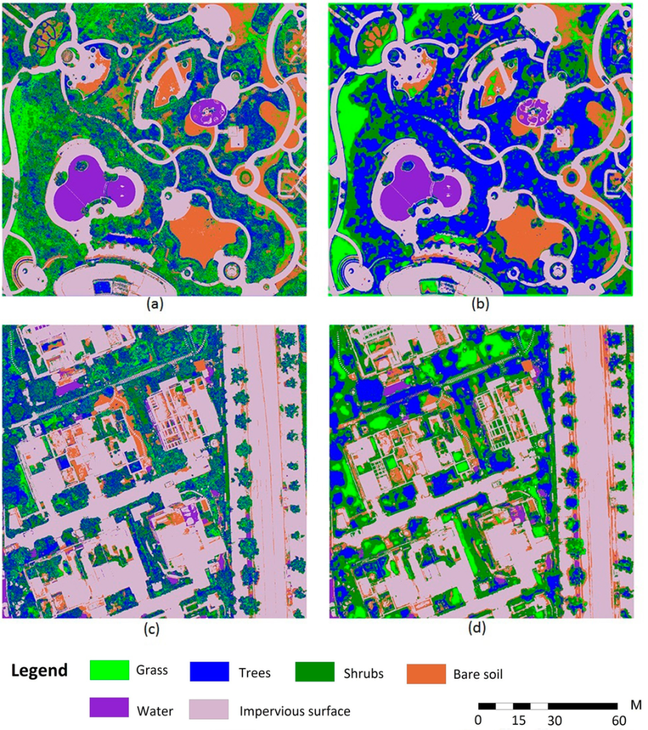
Classification results for RGB-only and RGB+GT31 using RF. (a) Image-A RGB-only; (b) Image-A RGB+GT31; (c) Image-B RGB-only; (d) Image-B RGB+GT31.
When classifying RGB-only images, both Image-A and Image-B show some “salt and pepper” effects. A large amount of trees were misclassified into grass and shrubs severely. This is mainly due t
w spectral resolution of UAV images and the lack of a NIR band reduces the separability of each land cover types. However, the inclusion of texture improves the classification accuracy from a visual point of view.
The study demonstrates that UAV is an outstanding platform for urban vegetation monitoring. The hybrid method can provide accurate classification results to reduce the drawbacks of off-the-shelf digital cameras. However, cameras incorporating a NIR band should be used for serious data acquisition in future works and validation of the proposed method should be extended to images from different areas and different time of the year. The comparison between the proposed method and the smoothed version of pure RGB classification results should be conducted. Finally, the uncertainty analysis of the proposed method should also be considered.
Source: UAV Remote Sensing for Urban Vegetation Mapping Using Random Forest and Texture Analysis – Feng, Q.; Liu, J.; Gong, J. UAV Remote Sensing for Urban Vegetation Mapping Using Random Forest and Texture Analysis.Remote Sens. 2015, 7, 1074-1094.