
Today I was wondering while thinking about what I should post on GIS Resources. Then suddenly I got a click, why not about What is Georeferencing or what is georeferencing means?
It seems to be a very easy term but for beginners some sometimes quite confusing. Let’s have a look in deep.
Before I move to What is Georeferencing, I would like to explain a few Geospatial terminologies like Spatial Data, Coordinate System, Datum and Map Projection. These terms have a significant meaning and importance while geo-referencing (how we will see down the line).
What is Spatial Data?
Positional information of features either on the surface of the earth or on the map is called spatial data. Spatial data can be abstracted into three main categories points, lines and areas.
- Point: Spatial data with no or zero dimension, no direction and no area.

Figure 1: Point Feature
- Line: Spatial data with one dimension, direction and no area.
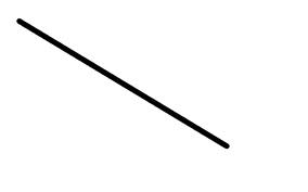
Figure 2: Line Feature
- Area: Spatial data with two dimensions.
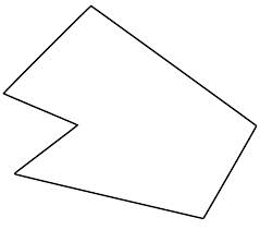
Figure 3: Area or Polygon Feature
Digital spatial data can be represented in one of the two systems called Vector or Point system and Raster or Cell system.
In a vector system, points are represented by a single pair of (x, y) Co-ordinate, lines by a series of (x, y) Co-ordinate pairs and areas by a series of (x, y) Co-ordinate pairs where first and last points are same.
In a raster system, points are represented by single cells, lines by a sequence of neighbouring cells and area by a collection of continuous cells.
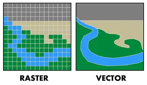
Figure 4: Raster and Vector Data Representation
Coordinate System:
It is a system by which the coordinates of any position on the surface of the earth can be determined on itself or a map or a computer screen.
Geographic Coordinate System (GCS) or Spherical Coordinate System (SCS):
The coordinate system on the earth’s surface is called a geographic coordinate system. In this system, position on the earth’s surface is measured in terms of latitude and longitude using angular units of measurement.
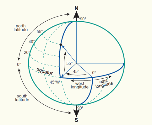
Figure 5: Geographic Co-ordinate System
Projected Coordinate System (PCS) or Cartesian Coordinate System (CCS):
A coordinate system on a map or a computer screen is called a projected coordinate system. It is the result of a projection from geographic coordinates using a projection method. In this system, a position on the earth’s surface is measured in terms of X coordinate and Y coordinate or easting and northing using a linear unit of measurement from an assumed origin.
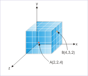
Figure 6: Cartesian Co-ordinate System
I will discuss more about the coordinate system in my next post.
Here is one important note:
Note: The coordinate of a point depends on its datum and projection. The coordinate of the same point differs when either its datum is changed its projection is changed or the parameters of projection are changed.
Datum:
A datum is a frame of reference for measuring locations on the surface of the earth. So far different ellipsoids have been developed closely fitting to the surface of the earth either or a part of it and they are called a datum. When datums are closely fit to the entire surface of the earth, they are global datums and when they are closely fitting to a particular portion of the surface of the earth they are called local datums.
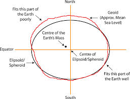
Figure 7: Global Datum and Local Datum
For establishing vertical control we use vertical datum such as Mean Sea Level or Geoid or EGM 96.
Horizontal controls are established using horizontal data such as WGS-84, and GRS-80.
Map Projection:
Representation of the earth’s curved surface on the flat surface either on a map or on a computer screen. For projection, the first datum is selected to model the surface of the earth.
There are different projection methods best suited to the area of map extent and preserving the map projection properties since the curved surface of the earth cannot be represented accurately on a flat surface.
Some of the common map projections are:
- Lambert Conformal Conic projection (LCC).
- Polyconic Projection
- Universal Traverse Mercator projection (UTM).
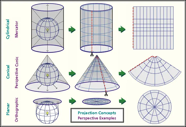
Figure 8: Map Projections
Now, I think understanding Georeferencing will be easier for all.
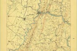
What is Georeferencing:
When co-ordinates of spatial dates are referenced to their corresponding positions on the surface of the earth then it is called Georeferencing of spatial data. Here data is registered with a coordinate system that is related to the earth’s surface which means a relationship is established between (x, y) coordinates on the map or the computer screen and its corresponding latitude, and longitude coordinates on the earth’s surface.
To achieve this, the first datum is selected to model the surface of the earth. Then the latitude and longitude coordinates on the datum surface are projected onto a paper or on a computer screen which is called map projection.
Figure 9: Georeferencing
After that spatial data of that area are referenced to the map projection by coordinate transformation.
Thus in Geo-referencing of spatial data, requires the knowledge of coordinate systems including datum, map projection and coordinate transformation.
The Process of Georeferencing
Georeferencing is the process of aligning spatial data (such as maps or images) to geographic coordinates, allowing them to be accurately placed within a coordinate system. This involves identifying known points on the image, assigning real-world coordinates to these points, and then applying a transformation to adjust the image accordingly.
Popular software tools used in georeferencing include ArcGIS, QGIS, ERDAS IMAGINE, Global Mapper, and GDAL, an open-source library that provides command-line tools for geospatial data manipulation. Accurate georeferencing ensures reliable spatial analysis, data integration, and applications in various fields such as navigation, resource management, and scientific research.
Step-by-Step Guide on How Georeferencing is Performed
- Collecting Reference Data:
- Obtain the image or map that needs to be georeferenced.
- Gather reference data (coordinates of known locations) from reliable sources such as GPS devices, maps, or existing GIS data.
- Preparing the Image:
- Load the image or map into the georeferencing software.
- Ensure the image is properly oriented and cropped if necessary.
- Adding Control Points:
- Identify and mark control points on the image. These are points with known geographic coordinates.
- Control points should be well-distributed across the image to ensure accuracy.
- Entering Coordinates:
- Input the real-world coordinates for each control point.
- Use a consistent coordinate system and datum for all control points.
- Transformation:
- Apply a transformation method to align the image with the real-world coordinates. Common methods include:
- Linear (affine) transformation: used for simple adjustments.
- Polynomial transformation: used for more complex distortions.
- Projective transformation: used for images taken from an angle.
- Apply a transformation method to align the image with the real-world coordinates. Common methods include:
- Checking Accuracy:
- Assess the accuracy of the georeferencing by checking the residuals (differences between the actual and transformed coordinates of the control points).
- Adjust the control points or add more if necessary to improve accuracy.
- Saving the Georeferenced Image:
- Once satisfied with the accuracy, save the georeferenced image in the desired format.
- Export the associated geographic data for use in GIS applications.
Conclusion
In conclusion, georeferencing is a critical process in GIS that involves assigning real-world coordinates to spatial data. Following a systematic approach and utilizing appropriate tools ensures accuracy and precision, which are paramount for reliable spatial analysis, data integration, and various applications in research, planning, and resource management.
Please share and like, if you find it useful.
Thank you!
Additional Resources
Issues to be addressed while georeferencing.


Very much helpful…
Thanks dear
you just made it simple to understand. i give you 5 stars. Thanks a lot
The concept of projecting points from the surface of the earth to the surface of an ellipsoid is easy to understand, in both cases the points are located using angular coordinates. The concept of projecting points from an ellipsoid to a surface that can be wrapped around that ellipsoid and latter unwrapped to make it flat, as a map, is also easy to understand. The need to use a grid to describe the position of points on the map using distance coordinates is also easy to understand. That was accomplished by establishing reference grid lines such as a prime meridian and a set of principal parallels. We applied those simple concepts to read and use maps long before we started to talk about georeferencing. What is difficult to understand, and it is not clear from the article, is why we didn’t need georeferencing before and why we need it today. In other words, is georeferencing different from the process of establishing the standard grids that we take for granted when we use state maps prepared in the California Coordinate System, for instance? Are not those maps already georeferenced?