
Archive

Image Processing Using IDL
Image Processing Using IDL IDL Version 7.1 May 2009 Edition Download Image Processing Using IDL “This blog does not host any contents or data. All the files linked to other website and

Getting Started with ENVI
Getting Started with ENVI (December, 2009 Edition) Download Introduction to ENVI “This blog does not host any contents or data. All the files linked to other website and the contents

Taiwan Develops its First Space Based GPS Receiver
In recent news, scientists in Taiwan have developed the nation’s first space-based Global Positioning System (GPS) receiver, detraction in the country’s reliance on foreign imports. “The first locally developed space-borne

What’s New in ENVI 5.1
This video highlights new functionality available in the latest release of the ENVI Platform including ENVI 5 SP3, ENVI LiDAR 3.2 SP1, ENVI Services Engine 1.0.1, and IDL 8.2.3
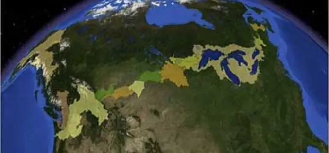
Linking U.S. and Canadian Border Waters
In recent news by USGS, seamless digital maps of surface waters along the Canada and United States International Boundary are now possible. These maps make tracking complex water issues easier to solve

World Bank Credits $153 Million to Odisha Disaster Recovery Project
In a recent news, World Bank has approves a $153 million to the state of Odisha in India to strength its capacity for disaster risk management and to build disaster

PR: PCI Geomatics Announces Support for Skybox Imaging’s Imagery in Geomatica 2013 SP3
RICHMOND HILL, Ontario, Canada—February 24, 2014: PCI Geomatics, a world leading developer of remote sensing and photogrammetric software and systems, announced today it supports data analysis of images from SkySat-1,

University of Lisbon Inviting Applications to a Scholarship for Master of Science Holder
The Higher Institute of Agronomy (ISA) is in Portugal, the largest and most qualified graduate in Agricultural Sciences graduate school and, with his expertise recognized nationally and internationally. With over 160
University of Lisbon Inviting Applications for a PhD Scholarship
The Higher Institute of Agronomy (ISA) is in Portugal, the largest and most qualified graduate in Agricultural Sciences graduate school and, with his expertise recognized nationally and internationally. With over 160

Esri Launches Geotrigger Service for Mobile Developers
Location-Based Messaging Added to iPhone and Android Apps with Minimal Battery Drain February 19, 2014, Redlands, California—Esri announced today that its cloud-based Geotrigger Service is now available, making it easier for developers to
