
Archive

Trimble Puts More Spatial Data in the Hands of Geospatial Professionals with its New InSphere Data Marketplace
Additional Enhancements to InSphere Applications Streamline Geospatial Data Access SUNNYVALE, Calif., Sept. 3, 2014—Trimble (NASDAQ: TRMB) announced today a new Data Marketplace service for the Trimble® InSphere™ geospatial information management

SuperGIS Webinar.: Bring Field to Office by Smart Devices
SuperGIS Webinar: Bring Field to Office by Smart Devices Thursday, September 18th – 05:00 PM – 06:00 PM (Taipei Time, GMT+8) Wondering how on-site survey tasks and office GIS work can be well connected
Deputy Prime Minister Announces Plans for a New Map of Accessible Green Space for England and Wales
03 Sep 2014 – The Deputy Prime Minister, Nick Clegg, today announced that Ordnance Survey would compile and release data to allow for a new map of every publicly accessible green
OSGeo-Live 8.0 Released
29 Aug 2014-Version 8.0 of the OSGeo-Live GIS software collection <http://live.osgeo.org/> has been released, featuring over 50 open source, standards compliant geospatial applications. Lubuntu 14.04.1 LTS We have moved from Xubuntu to
Where Is It?
This video features some spectacular imagery from Earth-observing satellites. From this perspective, even some of the most familiar places can be difficult to recognise. Can you place these images on
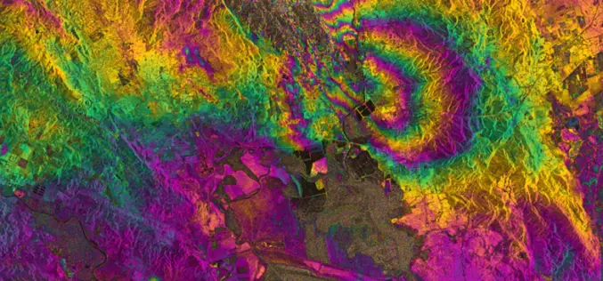
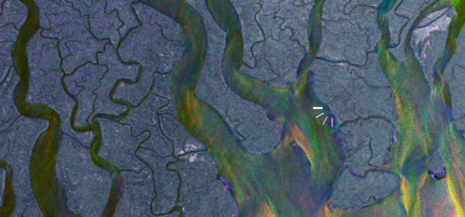
RADAR Vision Maps Napa Valley Earthquakes
Sentinel-1A has added yet another string to its bow. Radar images from this fledgling satellite have been used to map the rupture caused by the biggest earthquake that has shaken
Latest SuperGIS Desktop 3.2 Enhances Map Display Performance and Analysis Functions
Developed by Supergeo, the latest Desktop GIS, SuperGIS Desktop 3.2 now provides users with a more powerful and comprehensive platform to display and edit GIS data by improving stability, accelerating

SuperGIS Assists South Africa in Economy Planning and Development
Supergeo Technologies, the global leading GIS software and solution provider, announces that Mangaung Metro Municipality (MMM), South Africa, utilizes SuperGIS Desktop and SuperSurv to evolve the city economic development. The

Gogoi Calls for Proper Mapping of Human Trafficking Areas
Assam Chief Minister Tarun Gogoi on Monday called for proper mapping of areas from where incidents of trafficking of children and women are reported. Gogoi, who chaired a review meeting
