
Archive
Upgraded Extensions of SuperGIS Desktop Provide More Insights
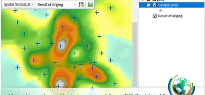
Before the end of this July, Supergeo will release a new update of SuperGIS Desktop 10 along with brand-new SuperGIS Spatial Statistical Analyst and Biodiversity Analyst. Developed by Supergeo Technologies
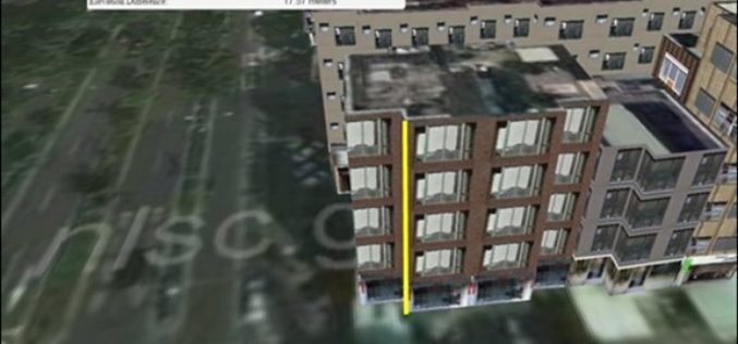
Managing Assets from Different Angles- SuperGIS 3D Earth Server
3D visualization is an important breakthrough in how geographic data could be displayed on the computer. Instead of the traditional 2D form, SuperGIS 3D Earth Server can easily present data
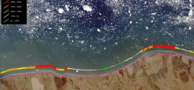
TCarta Marine Changes the Way Dynamic Environments are Managed and Monitored with Introduction of Vector Shorelines
DENVER, Colorado, USA, 8 August 2017 – TCarta Marine has made the world’s most dynamic environments easier to monitor and manage with the introduction of its new multi-scale Shoreline Products. Offered in

Leica Webinar: Leica Captivate Pipeline: A Transformative Approach to Pipeline Surveying
Leica Captivate Pipeline: A Transformative Approach to Pipeline Surveying Tue, Aug 8, 2017 11:00 AM – 12:00 PM PDT With more than 30,000 miles of pipeline planned and under construction
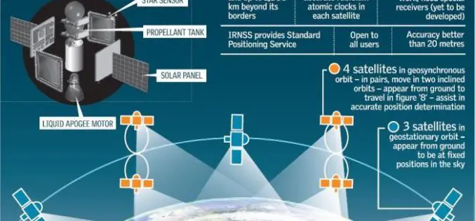
Isro to Sign MoU with CSIR-NPL for Time and Frequency Traceability Services for NavIC
According to recent news reported by TOI, the Indian Space Research Organisation (ISRO) will on Friday sign an MoU with CSIR-National Physical Laboratory (NPL) for time and frequency traceability services. The move

TerraGo Mobile Apps Add New Advanced Mapping Features and Laser Range Finder Integration
TerraGo Mobile Apps Add New Advanced Mapping Features and Laser Range Finder Integration TerraGo Edge 4.1 and any app created with the TerraGo Magic zero-code app platform includes enhanced mapping and surveying features

3DR Site Scan Processing Now Powered by Pix4D
Site Scan customers can now create more accurate, detailed data products than ever before 3DR, makers of Site Scan, one of the leading drone data platform for engineering and construction,

Harxon Releases Rover Radio for RTK Surveying and GNSS Positioning
Harxon has introduced an advanced, high-speed, Bluetooth-enabled wireless rover radio.The HX-DU1603D, designed for GNSS/RTK surveying and precise positioning, will be showcased this September at the Intergeo trade show in Berlin. The HX-DU1603D

Flood Monitoring using SCATSAT-1 Satellite
Monsoon was active over different regions of India especially in Gujarat, Eastern Uttar Pradesh, Western Bihar, Assam and lately in West Bengal during mid July 2017. Heavy rains have created

Embarcadero and TatukGIS Announce New Tool for RAD Studio
Latest geographic information system development kit allows RAD Studio developers to create desktop, client-server and mobile GIS apps AUSTIN, Texas–(BUSINESS WIRE)–Embarcadero Technologies (a division of IDERA) and TatukGIS today announced that TatukGIS has released
