
Archive
Drone Delivery Canada Receives $7 Million from Warrant Acceleration
Toronto, ON, February 26, 2018, Drone Delivery Canada ‘DDC or the Company’ (TSX.V:FLT OTC:TAKOF), is pleased to report the Company has received $7.0 Million from the exercise of warrants which the
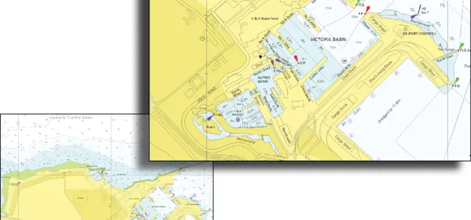
South African Nautical Charts Now Available from East View Geospatial
MINNEAPOLIS, Minn. – February 27, 2018 – East View Geospatial (EVG) is pleased to announce that it has expanded its nautical chart offerings via an agreement with the South African Navy

EuroGeographics Announces New Additions to Open Data for 2018
February 20, 2018 – EuroGeographics has released a new version of EuroGlobalMap, its open data created from official national sources. Forty-five members of the Association for the European National Mapping, Cadastral
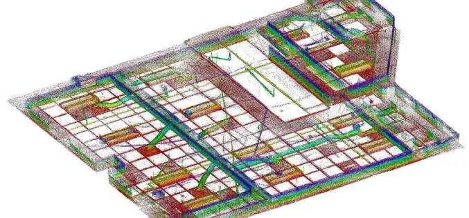
GeoSLAM to Demo Time & Cost Saving 3D Mobile Laser Scanners for Construction Applications at 2018 AGC Convention
NOTTINGHAMSHIRE, U.K., 20 February 2018 – GeoSLAM will demonstrate how its ZEB-REVO RT handheld laser scanner can be used to slash the time and cost required for complex indoor 3D mapping on

Bangalore Started Rooftop Solar Energy Potential Mapping Using Aerial LiDAR
According to recent news reported by The Hindu, Over the fortnight, a helicopter armed with LiDAR system will fly across the city, mapping its potential to generate rooftop solar energy. The

Hexagon Announces Next Generation Leica Rugby Lasers – The First Upgradable Lasers for Construction
February 15, 2018 – Hexagon, a leading global provider of information technology solutions, launched today the Leica Rugby CLH and Leica Rugby CLA lasers. This next generation of lasers offer the

OGC Seeks Public Comment on Web Coverage Service (WCS) 2.1 Candidate Standard
Updated WCS 2.1 Standard will simplify access to spatio-temporal ‘big datacubes’ February 15, 2018 – The Open Geospatial Consortium (OGC) seeks public comment on the Web Coverage Service (WCS) 2.1 candidate

DroneDeploy Launches Real-Time Mapping for Instant Aerial Data and Analysis
Live Map Creates Instant Drone Maps on iOS Devices, Allowing Decision-Makers to Take Immediate Action SAN FRANCISCO – February 15, 2018 – (BUSINESS WIRE)–DroneDeploy, the leading drone mapping software platform in the

Global Mapper v19.1 Now Available
Global Mapper v19.1 Now Available with 3D Profile Line Exporting, Multivariate Querying, and Expanded Drag-and-Drop Window Docking Blue Marble Geographics is pleased to announce the release of Global Mapper version
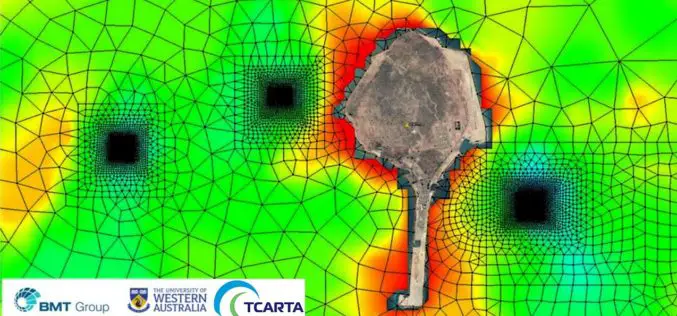
Satellite Derived Bathymetry from TCarta Plays Key Role in Aquaculture Siting Project
Fish Farms in Arabian Gulf BRISTOL, United Kingdom, February 14, 2018 – British Engineering and Scientific Consultancy Firm, BMT, is using Satellite Derived Bathymetry from TCarta as a critical dataset
