Satellite Derived Bathymetry from TCarta Plays Key Role in Aquaculture Siting Project
Fish Farms in Arabian Gulf
BRISTOL, United Kingdom, February 14, 2018 – British Engineering and Scientific Consultancy Firm, BMT, is using Satellite Derived Bathymetry from TCarta as a critical dataset in the selection of new fish farming sites in the Arabian Gulf. BMT is performing the site selection work on behalf of Environment Agency – Abu Dhabi (EAD).
“Aquaculture development is emerging as a major market for highly accurate bathymetric data products,” said David Critchley, CEO of TCarta, a global provider of marine and terrestrial geospatial solutions based in Bristol, UK.
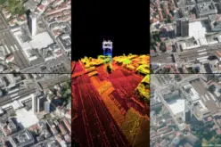
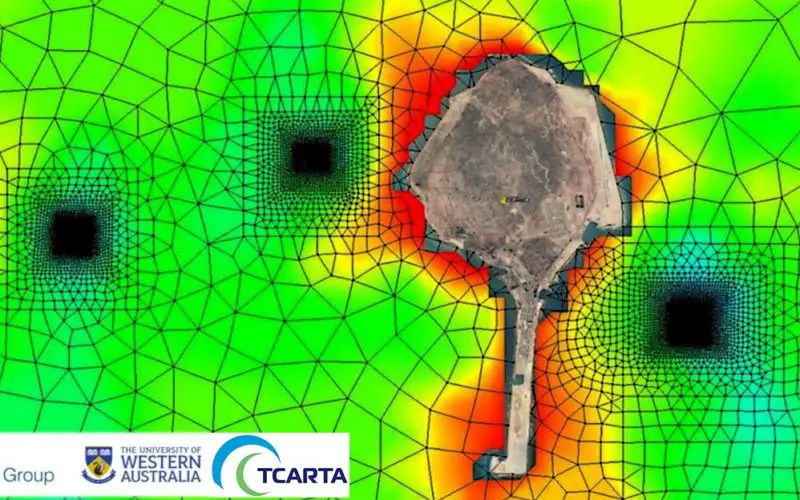
As a primary input for the modeling phase of the project, BMT obtained five-meter resolution Satellite Derived Bathymetry (SDB) products from TCarta for the waters around Delma. BMT also used TCarta Marine Habitat Maps, which differentiate the surface compositions of the seafloor around the island in waters to approximately 10 meters deep. TCarta created the Satellite Derived Bathymetry and Marine Habitat Map products for EAD during a 2015 environmental mapping project conducted by Abu Dhabi.
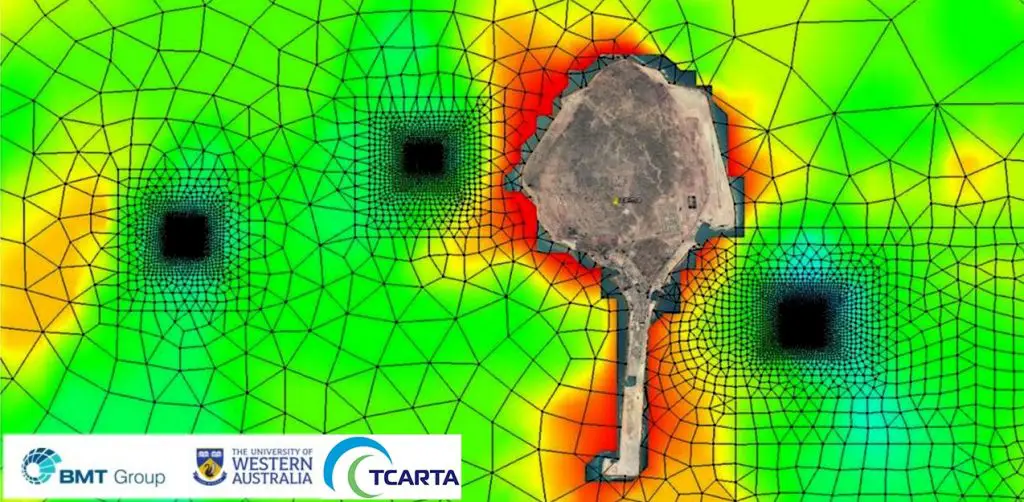
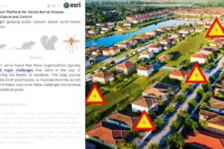
Proposed fish farming sites in the Arabian Gulf modelled using TCarta’s satellite derived products and services
Principal Marine Ecologist, Dr. Glenn Shiell explains, “The SDB product has proven a high quality, cost effective data set. A key benefit was the immediate availability of the data, which enabled us to commence building our model almost immediately – thus avoiding delays associated with planning and executing aerial or vessel assisted surveys.”
BMT used the TCarta data sets in its hydrographic modeling software to select ideal fish farming sites based on two key criteria. First, the chosen offshore locations must fall within certain maximum and minimum water depth thresholds to accommodate the large fish cages. And secondly, the cages must be placed in areas such as natural subsurface channels where water currents will continuously flush waste from the enclosures and keep the growing fish healthy.
The TCarta products provide the information required for BMT to perform these assessments accurately and quickly.
“Our Satellite Derived Bathymetry and related Habitat Maps are economically appealing for aquaculture development projects because they offer excellent resolution and accuracy at a great price,” said TCarta’s Critchley. “Satellite Derived Bathymetry is captured at about one tenth the cost of traditional marine survey data.”
TCarta commercialized the proprietary process to extract accurate seafloor depth measurements, as well as seabed surface classifications, from high-resolution satellite imagery. In the technique, 8-band multispectral imagery from the DigitalGlobe WorldView satellites is processed to derive the subsurface information. The resulting bathymetric data has an accuracy of two meters to a depth of 20 meters.
In addition to its financial and quality appeal, the TCarta data derived from satellite imagery offers several other benefits. First, it can be collected and processed in a matter of days, generally much faster than a ship- or airborne survey can be carried out. The remote collection of imagery by satellite poses no risk to personnel or the environment. And the bathymetric data can be captured in all parts of the world, even where security restrictions limit operation of aircraft or ships.
TCarta has also made Satellite Derived Bathymetry products easy for customers to obtain. In September, the UK firm launched its Bathymetrics online portal. This online site allows customers to search for the availability of off-the-shelf TCarta products, including Satellite Derived Bathymetry and 90-meter bathymetric datasets. Clients can view thumbnails, place an order and instantly download the purchased products.
“The Bathymetrics Portal allows customers to search for bathymetric data covering their area of interest and then buy just what they need,” said TCarta’s Critchley. “Data is priced by the square kilometer, and the minimum purchase is only $200.”
Visit the TCarta Marine Bathymetrics site at https://bathymetrics.shop/.
About TCarta (www.tcarta.com)
TCarta was established when TCarta Marine U.S. merged with Proteus Geo UK to create global bathymetric and marine datasets extending from the shallow coastal zone to the continental shelf. The international firm maintains offices in Denver, Colorado, and Bristol, UK. The TCarta product lines includes high-resolution satellite-derived water depth and seafloor map products as well as 90- and 30-metre GIS-ready bathymetric data aggregated from numerous information sources.
New TCarta Contact Information
TCarta UK
13-14 Orchard Street
Bristol
BS1 5EH
TCarta USA
3015 W 9th Ave
Denver
CO 80204 USA
1.303.284.6144
Email: info@tcarta.com
Website: www.tcarta.com