
Posts From GIS Resources
INTERGEO 2016 – Key Topic: Smart City
Karlsruhe, 3 May 2016 | By taking “Smart City” as a key topic, INTERGEO 2016 is focussing on a multi-faceted issue that will shape the future. The preview of the
Minister of Railways Launches One E-enabled application for Proper Monitoring of all the Railway Projects
Minister of Railways launches one E-enabled application, namely, Project Management & Information System (PMIS) for proper Monitoring of all the Railway projects throughout the country This Application will be able

Leica Captivate Experience Continues with Self-learning GNSS, Dynamic Lock for MultiStations
Leica Geosystems, industry leader of measurement technology, has announced the Leica Viva GS16 and updated Leica Captivate and SmartWorx Viva software. The GS16 is a truly self-learning GNSS receiver, able

Ph.D. Position in “Co-location of Space Geodetic Techniques”
The Chair of Mathematical and Physical Geodesy, as part of the Institute of Geodesy and Photogrammetry, has its main research and teaching focus on space geodesy and navigation, especially the

PrecisionHawk And DJI Deliver Easy-To-Use Drone And Data Packages For Farmers
The pre-assembled package, which includes DJI’s hardware platform plus PrecisionHawk’s flight and analytics software, is seamlessly integrated to provide a cost-effective and easy remote sensing tool for agriculture PrecisionHawk and

NASA ARSET Training: Using NASA Remote Sensing for Disaster Management
NASA ARSET Training: Using NASA Remote Sensing for Disaster Management 06/09/2016 to 06/30/2016 Times: 11:00 a.m.-12:00 p.m. and 6:00-7:00 p.m. EDT (UTC-4) NASA remote sensing and modeling resources are useful for

Maha Govt Plans to Map Whole State Using Satellite Images
According to recent news by ToI, the Maharashtra state government has planned to develop Maharashtra Geo-Spatial Digital Database System (MGDDS). City-based Maharashtra Remote Sensing Application Centre (MRSAC) has been appointed

Satellite Reveals Decline in the Number of Forest Fires in Uttarakhand
According to recent news by The Hindu, Satellite images show that there’s been a decline in the number of forest fires in Uttarakhand since April 28. Though fires in the

UNITAR and Esri Host Annual Conference in Geneva
Renowned Speakers Explore Use of Location-Based Tools to Support Sustainable Development Goals Earlier this week, the United Nations Institute for Training and Research (UNITAR) andEsri announced the featured speakers at
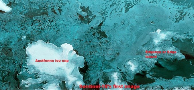
The First Images of Sentinel-1B
Launched on 25 April from Europe’s Spaceport in French Guiana, Sentinel-1B has produced its first images only two hours after the radar was switched on – a record time for
