Chinese Scientists Develop Advanced Remote Sensing Data Completion Model to Address Satellite Data Gaps
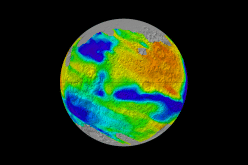
Chinese researchers have developed a groundbreaking remote sensing data completion model designed to address persistent data gaps in satellite ocean observations. This remote sensing data completion model, known as the Generalized Data Completion Model (GDCM), aims to reconstruct missing measurements caused by satellite orbit coverage gaps and cloud cover.
By leveraging deep learning techniques, the remote sensing data completion model effectively fills in these gaps, enhancing the accuracy and reliability of oceanic data.
Developed by scientists from the Institute of Oceanology of the Chinese Academy of Sciences (CAS) and the University of CAS, the GDCM utilizes spatio-temporal information within remote sensing data to accurately reconstruct key oceanic variables.
Also Read – China’s GeologyObserver-1 Revolutionizes 3D Mapping
These variables include sea surface temperature, wind speed, water vapor, cloud liquid water, and precipitation rate. The model’s innovative approach involves using seven consecutive days of observation data as inputs, enabling it to capture dynamic change patterns and significantly improve data completion capabilities, particularly in areas affected by cloud cover.
The research, published in the journal Remote Sensing of Environment, highlights the model’s effectiveness in providing gap-free and cloud-free oceanic data. This advancement is crucial for understanding the global climate system, as ocean remote sensing data plays a vital role in climate research and monitoring.
By offering a generalized solution applicable to multi-source remote sensing data, the GDCM contributes to more comprehensive and supportive ocean science research and related applications.
The development of the GDCM represents a significant step forward in addressing the challenges posed by missing data in satellite observations. Its ability to reconstruct accurate and reliable oceanic data has the potential to enhance various applications, including climate modeling, weather forecasting, and environmental monitoring.
As the demand for high-quality remote sensing data continues to grow, innovations like the GDCM are essential for advancing our understanding of Earth’s complex systems.
Source: Xinhua