
Global Positioning System

Trimble Tackles GNSS Spoofing with First Multi-Constellation Anti-Spoofing Tech
GNSS spoofing has become a regular occurrence with the potential for severe consequences when precise and reliable positioning is critical. Legacy GNSS signals are the primary target for bad actors,

Strengthening GNSS Resilience: Trimble Leadership on IonoGuard Innovation and Solar Cycle 25
As the effects of Solar Cycle 2025 intensify, industries dependent on precise positioning—such as surveying, agriculture, construction, and autonomous systems—are facing growing challenges due to ionospheric disturbances. In response to

Leidos Advances Quantum Technology Navigation to Tackle GPS Jamming
Leidos is spearheading efforts to develop quantum technology navigation systems designed to protect critical infrastructure from GPS jamming and spoofing attacks. As GPS signals grow increasingly vulnerable to both military

GPS III SV08 Launch Strengthens Anti-Jamming GPS Technology for U.S. Military
The U.S. Space Force has taken a major step forward in secure navigation with the successful launch of GPS III SV08, a next-generation satellite designed to enhance anti-jamming GPS technology.
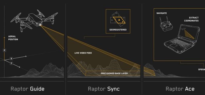
Maxar’s Raptor Software Sets New Standard for GPS-Denied Drone Navigation
In an era where GPS interference and jamming pose significant challenges to autonomous systems, Maxar Intelligence has unveiled a powerful solution—Raptor. This first-of-its-kind software suite is specifically designed to enable
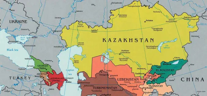
Kazakhstan Introduces National Geodetic Coordinate System to Enhance Spatial Data Infrastructure
Kazakhstan has launched its National Geodetic Coordinate System to strengthen its spatial data infrastructure, ensuring accurate geospatial information for various sectors, including land management, urban planning, and environmental monitoring. The

RMIT Australia Partners with India for GPS Alternative Development
RMIT University is collaborating with Indian microchip manufacturers and Australian air traffic management company Skykraft to develop an alternative to the U.S.-owned Global Positioning System (GPS). This initiative is supported

Nigeria Geodetic VLBI Project: A Leap in Geodesy and Technology
Nigeria recently marked a significant milestone in its scientific and technological landscape with the groundbreaking ceremony for the country’s first Geodetic VLBI project. The event, held at the Center for
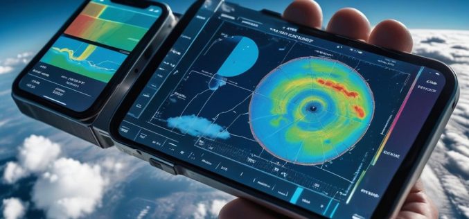
Mobile-Based Ionosphere Mapping To Enhance GPS Accuracy
In a significant leap forward for atmospheric science, researchers have successfully used data from millions of Android phones to map the ionosphere, an area of Earth’s upper atmosphere crucial to
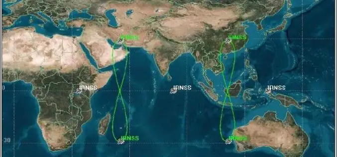
Access to ISRO’s NavIC Soon on Your Phone
India’s navigation capabilities are advancing as ISRO expands NaVIC (Navigation with Indian Constellation) to civilian use and access to mobile phones. NaVIC, formally known as IRNSS, which comprises seven satellites
