
Remote Sensing
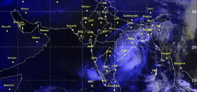
Severe Cyclonic Storm ‘HUDHUD’ over westcentral Bay of Bengal
According to Indian Meteorological Department, the Severe Cyclonic Storm ‘HUDHUD’ over westcentral Bay of Bengal moved northwestwards, intensified into a very severe cyclonic storm and lay centered at 1430 hrs IST

Venezuela to Launch Earth Observation Satellite”Sucre” in 36 Months
In recent news by Shanghai Daily, the manufacturing and launching of Venezuela’s third earth observation or remote sensing satellite will take some 36 months with the help of Chinese technology,
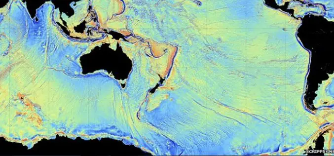
CryoSAT Unveils Secrets of the Deep
ESA’s ice mission has been used to create a new gravity map, exposing thousands of previously unchartered ‘seamounts’, ridges and deep ocean structures. This vivid new picture of the least-explored

Iran to Launch 4 Satellites
In recent new, Iran is planning to launch four new satellites with domestically-designed carriers into the space in the near future. The four satellites are named as Sharif Sat, Zafar (Triumph), Tolou

China to Build Comprehensive EO System in 10yrs
Beijing: China plans to build an earth observation system that integrates use of air, space and ground based technology, including drones, satellites and GPS systems in the next ten years, a top
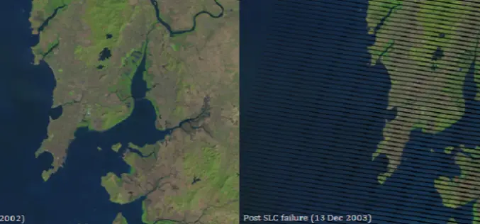
Gap-Filling Landsat 7 SLC-off data using ERDAS and ENVI
On May 31, 2003, the Scan Line Corrector (SLC), which compensates for the forward motion of Landsat 7, failed. Subsequent efforts to recover the SLC were not successful, and the

India Sings MoU with China on Peaceful Use of Space
September 20, 2014: In a visit to India, Chinese President Xi Jinping signed a series of documents with India at the Hyderabad House in New Delhi, strengthening ties between the
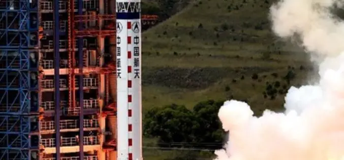
China Launches Remote Sensing Satellite – Yaogan-21
In recent news,China has successfully launched Yaogan-21, a remote sensing satellite on September 8, 2014 from Taiyuan Satellite Launch Centre. A Long March-4B carrier rocket carries Yaogan-21 and Tiantuo-2 satellite,
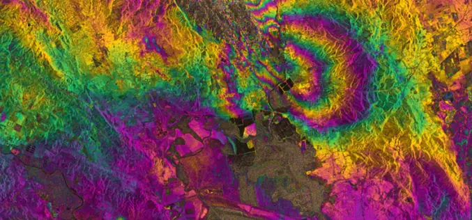
RADAR Vision Maps Napa Valley Earthquakes
Sentinel-1A has added yet another string to its bow. Radar images from this fledgling satellite have been used to map the rupture caused by the biggest earthquake that has shaken

First images taken with Exelis system on DigitalGlobe’s WorldView-3 satellite released
Exelis-built integrated super-spectral imaging system consists of a telescope, sensor and shortwave infrared system ROCHESTER, N.Y., Aug. 26, 2014 – DigitalGlobe has released the first images taken with the Exelis-built (NYSE: XLS) integrated,
