
Webinars

SuperGeo Webinar: Top 10 Features SuperGIS Desktop
SuperGeo Webinar: 10 Most Useful Features of SuperGIS Desktop 5th February, 11:00 AM – 11:30 AM (India Standard Time) Are you looking for powerful and comprehensive GIS solutions? Something that may

Webinar: Unmanned Aerial Systems for Mapping
Webinar: Unmanned Aerial Systems for Mapping January 15, 2015: 10:00 am to 11:00 am Unmanned Aerial Systems (UAS) or drones have garnered a lot of headlines recently. The term “drone”

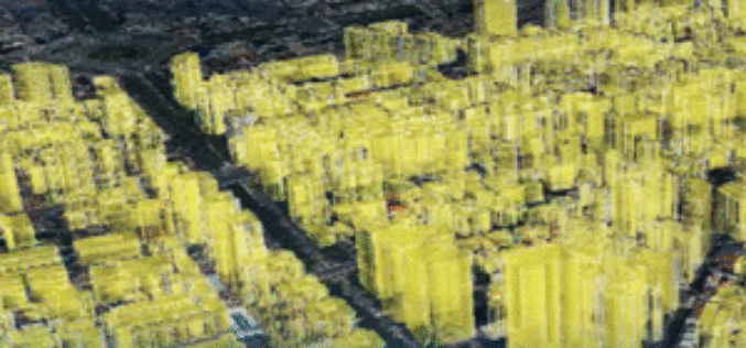
3D Urban Modeling using Geomatica, CityEngine and 3D FeatureXtract
3D Urban Modeling using Geomatica, CityEngine and 3D FeatureXtract On-demand webinar: If you have access to high resolution stereo imagery over your area of interest, you can easily model 3D
Webinar: Geomatica 2014 and LiDAR for Accurate DEM Creation
Geomatica 2014 and LiDAR for Accurate DEM Creation On-demand webinar: Digital Elevation Models (DEMs) play an important role in terrain-related GIS applications. Chief among the many factors that affect the

Live Webinar: A Simple App to Track your Mobile Workers, Cut Costs and Boost Productivity
Webinar: A Simple App to Track your Mobile Workers, Cut Costs and Boost Productivity Tuesday, December 9th from 12-12:30 PM ET By knowing the location of your mobile workers, you

Webinar Trimble TerraFlex: Introducing Data Update Workflows
Trimble TerraFlex: Introducing Data Update Workflows December 10, 2014 Register for 8am MST (4:00pm Paris) Register for 4pm MST (10:00am Sydney) Trimble® TerraFlex™ software—the flexible, configurable, cross platform solution for

Blue Marble Webinar – Geographic Calculator 2014: Working with Transformations
Geographic Calculator 2014: Working with Transformations December 9, 2014 at 2:00 pm (EST) One of the common questions we receive here is “How do I know which transformation to choose?”
SuperGIS Webinar: Monitor Environment Changes with 3D GIS Tech
Supergeo is going to hold a webinar to show how 3D GIS can be applied to rapid changes of natural and urban environments with SuperGIS 3D Earth Server 3.2, the
Webinar: SAR Tools and Capabilities in Geomatica 2014
On-demand Webinar – SAR Tools and Capabilities in Geomatica 2014 In this one-hour webinar, PCI experts will demonstrate data processing techniques in Focus including ingesting, calibrating and displaying SAR data.
Webinar: Using GPS with Global Mapper
Using GPS with Global Mapper November 20, 2014 at 11:00 am (EST) Over the last decade, GPS positioning technology has become increasingly ubiquitous. It is built into our cars, our
