CORS Network to Complete Digital Land Resurvey in Kerala
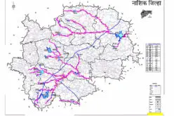
Kerala State Government has given a nod to extended Digital Land Resurvey for 1,550 villages at cost of ₹807.98-crore. The project is expected to complete the resurvey of land over four years in four phases.
The project aims to do away with conventional methods of land surveying and to adopt new technologies. The new technologies are aimed at unifying land-related documentation under the departments of revenue, survey, and registration.
K. Rajan, Minister for Land Revenue, Survey and Land Records, Land Reforms, Housing, Government of Kerala said that administrative sanction has been given for the first phase which will cover 400 villages at a cost of ₹339.43 crores under the Rebuild Kerala development program.
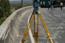
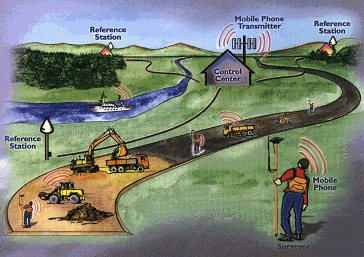
The Department of Survey and Land Records will implement the project with technical support from the Regional Director (Kerala), Survey of India. The department will primarily bank on Continuously Operating Reference Station (CORS) networks using Real-Time Kinematic (RTK) machines for the digital resurvey. Twenty-eight base stations will be set up in the State. The resurvey using conventional methods was launched in Kerala in 1966.
The CORS network term is adopted by the National Geodetic Survey, an office of the United States Department of Commerce’s National Oceanic and Atmospheric Administration (NOAA), is a sophisticated and advanced GPS/GNSS based technology that first requires the precise determination of a position on the surface of the earth and then the continuous monitoring of that precise position for Geoscientific studies that include determining the shape of the earth, determining the effect of the earth-moon gravitation on the shape and rotation of the earth, determining the movement of the earth’s crust, defining a Spatial reference System and so on.
The GPS/GNSS receiver is the heart of a CORS network configuration. To support a wide realm of activities, the receiver must be a high-quality geodetic unit capable of tracking and recording all components of the GPS/GNSS signal. Rapid GPS/GNSS technology advances have enabled GPS/GNSS technology to become more robust and versatile. The applications derived from a network of CORS have found use in determining precise position on a 24×7 real-time basis for civilian use that has been shown to save time and cost of execution of developmental projects.
The solution provided would define positional accuracy with data correction from the CORS network on the concept of VRS (Virtual Reference Station). Correction and all the CORS data streamed to a master control center for better control and monitoring of data, with one redundant control station for uninterrupted service in case of maintenance or updating of data center and communication.
CORS will be used in 60% of the villages, while drone-plus-LiDAR mapping and Electronic Total Station (ETS) systems will be used in 20% of locations each.
Four hundred villages will be taken up in the first phase for which ₹339.43 crores has been earmarked. For the second, third, and fourth phases, ₹156.17 crores, ₹156.18 crores, and ₹156.18 crores respectively have been provided.
K. Rajan, Minister for Land Revenue, Survey and Land Records, Land Reforms
The project covers all villages, excluding 87 villages where the exercise was completed using total station surveying solutions and 29 villages where it is in progress. In every village, the government lands will be surveyed first followed by privately owned lands. Using CORS or LiDAR, one surveyor and one helper can survey four hectares at a time.
The four-year-long project also aims to facilitate the issue of Record of Rights (RoR), online services in the department, settlement of land-related disputes, and preparation of accurate documentation and sketches about land. It will also help tackle encroachments on government land, and assist disaster management.
A State-level project monitoring unit will be formed at the Department of Survey and Land Records. District-level implementation units will be headed by the district collectors. A high-level panel headed by the Chief Secretary will assess the progress of work.
Source – The Hindu
Also Read –
UAV Mapping for Land Record Modernization