Exploring the Power of IBM Environmental Intelligence APIs for Geospatial Insights
The IBM Environmental Intelligence APIs are designed to equip data scientists and developers with high-quality environmental data sets. These APIs offer a comprehensive set of geospatial, climate, and weather data, as well as pre-trained AI models.
The platform simplifies the integration of environmental data into business applications, providing users with the ability to make better decisions, mitigate risks, and respond proactively to climate-related challenges. It’s currently free to use, making it accessible to businesses and developers aiming to explore its capabilities.
What are IBM Environmental Intelligence APIs?
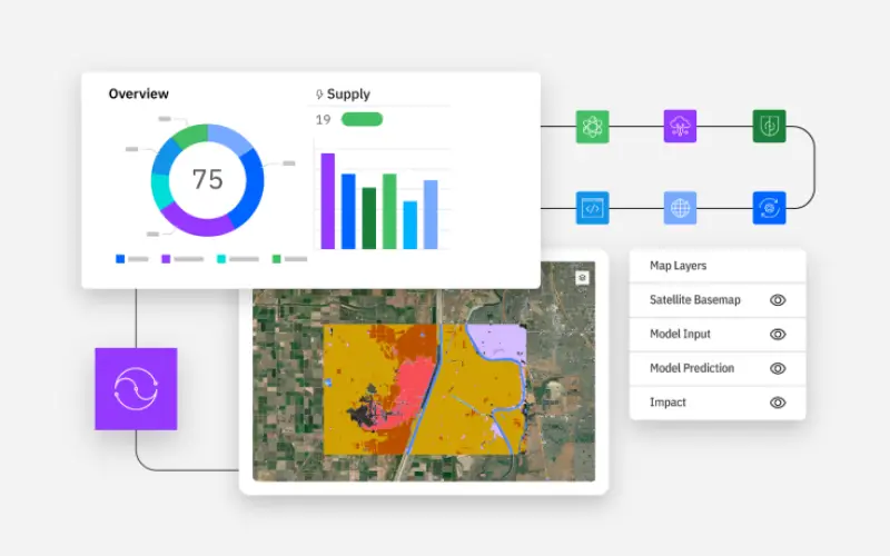
The IBM Environmental Intelligence APIs are a cloud-based solution that allows organizations to access a variety of curated environmental and geospatial data sets. These APIs include tools for analyzing satellite imagery, weather patterns, carbon emissions, and more. By offering pre-built models and data sets, IBM helps businesses streamline their data analysis, enabling them to act on environmental risks and opportunities more efficiently.
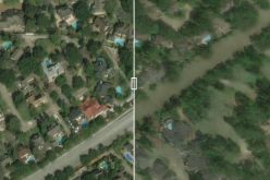
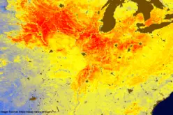
The platform’s core technology is centred on geospatial data layers, AI-powered models, and high-resolution satellite imagery. By leveraging these tools, companies can extract insights about climate risks, deforestation, carbon emissions, and more—all without needing to manage the complex processing tasks typically required for such data.
Also Read – The Impact of Climate Change is Being Researched using AI by IBM and NASA
Use Cases for IBM Environmental Intelligence APIs
The IBM Environmental Intelligence APIs have a wide range of applications across industries. Here are a few examples:
- Utilities: Energy companies can use weather data to predict outages, optimize repair schedules, and enhance customer service.
- Agriculture: Farmers can benefit from crop health insights and weather predictions to boost yield and minimize climate impact.
- Financial Services: Insurers and lenders can improve their risk assessments by leveraging predictive analytics for climate-related events.
- Government: Agencies can better advise the public during natural disasters by using weather and health data to forecast climate risks.
- Consumer Goods: Food companies can monitor their carbon footprint and ensure their supply chains meet sustainability standards.
Unique Features and Benefits
One of the standout features of the IBM Environmental Intelligence APIs is its ability to make complex environmental data accessible and actionable. The platform processes raw geospatial data—such as satellite images from NASA’s Landsat and the European Space Agency’s Sentinel satellites—and transforms it into useful information layers. This enables businesses to make data-driven decisions without needing deep expertise in geospatial technologies.
Here’s what sets IBM Environmental Intelligence APIs apart:
- Pre-trained Models: The platform offers pre-trained geospatial models, reducing the time it takes for data scientists to derive insights from satellite and weather data. These models rely on a mix of AI and machine learning techniques to improve accuracy.
- Scalable Data Sets: Users have access to curated, scalable environmental data sets, including wildfire risk potential, above-ground biomass estimation, and carbon emissions data. These can be easily queried and integrated into applications.
- Simplified Data Access: With easy-to-use APIs, data can be queried across spatial and temporal resolutions, offering insights into wildfire risks, atmospheric reflections, and more.
Applications and Underlying Technologies
At its core, the IBM Environmental Intelligence APIs integrate several technologies to make environmental insights easier to use:
- AI-Powered Models: AI is central to how the platform functions. One example is the Geospatial AI Foundation Model, which analyzes satellite data to provide consistent views of the Earth every few days. The model’s adaptability and accuracy make it ideal for applications that require detailed environmental insights.
- Geospatial Data Layers: The platform includes curated geospatial data layers that are processed and normalized for easy use. These include datasets from NASA’s Landsat, the European Space Agency’s Sentinel, and other public sources.
- Data Integration: The platform supports a wide range of use cases by integrating data from multiple sources. These include climate data, satellite imagery, and commercial weather information.
Conclusion
The IBM Environmental Intelligence APIs represent a powerful tool for companies seeking to leverage environmental data to gain insights, make informed decisions, and mitigate risks. Whether it’s helping utilities optimize operations, improving financial risk models, or enabling government agencies to respond to natural disasters, these APIs offer the data and tools necessary to address today’s environmental challenges.
With its scalable datasets, pre-trained AI models simplified data access, and the fact that it’s currently free to use, IBM’s platform stands out as a leader in environmental intelligence.
*Preview expires on February 28th, 2025
Source: IBM