
Tag "geospatial"
Exploring the Power of IBM Environmental Intelligence APIs for Geospatial Insights
The IBM Environmental Intelligence APIs are designed to equip data scientists and developers with high-quality environmental data sets. These APIs offer a comprehensive set of geospatial, climate, and weather data,
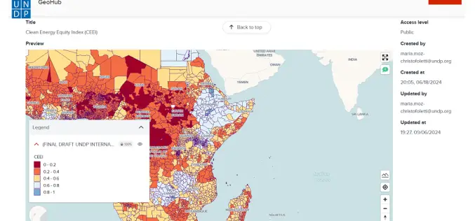
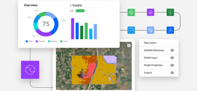
Advancing AI-Driven Energy Equity with Geospatial Technology
The United Nations Development Programme (UNDP) and IBM have launched two advanced models that combine AI and geospatial technology to promote clean energy access and equity. These tools, hosted on

Merkator and RMSI Partner to Accelerate Telecom Network Geospatial Transformation
Merkator, a leading provider of next-generation network inventory solutions for telecom operators, today announced a strategic partnership with RMSI UK, a global leader in geospatial solutions and services. This collaboration, via the MarlinDT
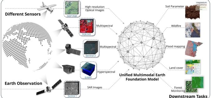
TorchGeo 0.6.0: Advancing Geospatial Machine Learning
TorchGeo 0.6 marks a significant step forward in geospatial machine learning by offering new datasets, data modules, and pre-trained models for satellite image analysis. Over 11 months, 23 contributors worked

What is Digital Twin and How Does It Work?
In today’s rapidly evolving technological landscape, Digital Twin technology has emerged as a groundbreaking innovation, especially in the geospatial sector. Digital twins are virtual replicas of physical entities that mirror

Intelpol by IGNESA Recognized for Excellence in Geospatial AI at Indian Icon Awards
IGNESA INDIA SOLUTIONS PRIVATE LIMITED, an innovative startup specializing in AI-driven geospatial solutions, has received a significant accolade at the Indian Icon Awards 2024. Their flagship product, IntelPol, was honored

Call for Proposals for Geospatial Technology and Solutions: Impact and Importance for India’s Future
The National Geospatial Programme (NGP) division, formerly NRDMS, calls for proposals in Geospatial Technology and Solutions that have the potential to impact various sectors in India significantly. The National Geospatial

Trimble’s New GNSS Base Station Gives Users Improved Satellite Tracking and Remote Operation for Civil Construction, Geospatial and Agriculture Applications
Trimble (NASDAQ: TRMB) has introduced the Trimble® R750 GNSS Modular Receiver, a connected base station for use in civil construction, geospatial and agricultural applications. The R750 provides improved base station
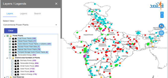
Geospatial Energy Map of India for Effective Planning of Resources
NITI Aayog in collaboration with the Indian Space Research Organisation (ISRO) has developed a comprehensive Geographic Information System (GIS) Energy Map of India with the support of Energy Ministries of Government

GIS Resources Magazine (Issue 3 | September 2021): Geospatial Technologies for Utilities Mapping & Monitoring
GIS Resources is pleased to announce the release of its 3rd edition (September 2021) of the print and digital magazine. The edition titled “Geospatial Technologies for Utilities Mapping & Monitoring.” Electricity,
