Global flood risk intelligence firm Fathom unveils the most complete and technologically advanced flood map for the US
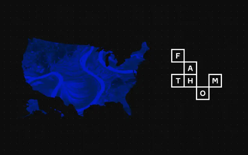
Fathom, a global leader in water risk intelligence, has released a new US Flood Map; a cutting-edge tool that provides the most comprehensive climate-driven flood risk information for the United States.
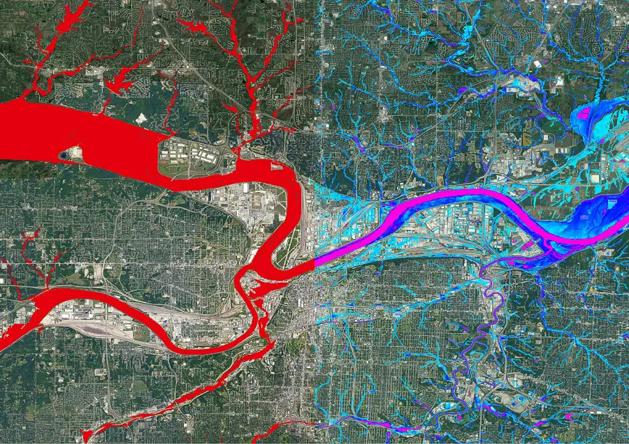
Responding to the inconsistent and incomplete coverage of existing datasets, the US Flood Map leverages the latest observation, terrain and climate information to present a consistent view of flood risk for all major flood perils, climate scenarios and time horizons. Thanks to its team of scientists, Fathom’s US Flood Map offers the most advanced hazard and risk information for the country, at 10m resolution.
Fathom’s US Flood Map empowers engineers, climatologists, GIS professionals and asset owners and operators to make swifter, more informed decisions for their projects at pace and with confidence, using this comprehensive resource. Offering a uniform view of current and future flood risk in the US, the flood map enables users to enhance risk assessment and climate risk reporting, and future-proof their assets.
The United States has experienced a significant increase in the severity, frequency and unpredictability of extreme weather events, due to factors such as climate change, natural variability, population growth and urban development. The impact of these catastrophes are immense and, if not mitigated sufficiently, will continue to impact critical infrastructure and put communities at risk. Emerging technology now means that we have more information than ever before to effectively manage exposure to flood risk in the US, and prevent unorganized development in high-risk areas.
Traditional approaches to mapping flood risk are highly detailed but not scalable due to resource, time and financial demands. Fathom’s methodologies, independently validated by organizations like USACE and built upon an array of scientifically robust and peer-reviewed research by Fathom’s scientists, enable efficient and robust flood hazard assessment without compromising accuracy.
Notable features of the US Flood Map include:
- Comprehensive coverage: Fathom’s US Flood Map is the first to cover every river, stream and coastline in the country, providing an unprecedented level of detail and accuracy.
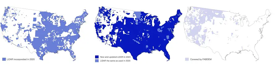
- Unrivaled terrain data: the most accurate US terrain data in existence, thanks to an increase of LiDAR data collected since 2020 (now covering 872,000sqkm of the US). Lower quality elements of the publicly available data are supplemented by Fathom’s bias-free global ground terrain map, FABDEM.
- Unparalleled representation: With FEMA’s coverage limited to major (approximately 60% of) river channels and prioritizing densely populated urban areas, Fathom’s US Flood Map offers a consistent and unified view of flood risk across the entire country and 100% of river channels.
- Climate conditioned: By integrating Fathom’s Climate Dynamics framework into the US Flood Map, Fathom is the only firm able to demonstrate the impact of climate change on flood risk under all emissions scenarios, temperature changes and time horizons up to the year 2100.
- Updated methodology: A revised methodology provides the most complete flood defense dataset.
- Dam simulation: Using a machine learning model trained on all available observations, Fathom has, for the first time, estimated the influence of all 84,000 dams on extreme flows nationwide. In addition, by applying detailed land use and building data to varying surface parameters, the new US Flood Map explicitly simulates how land use impacts the flow of water across the entire country; an unrivaled feature.
- Risk Scores: Distilling complex depth-frequency data into an easily digestible and consistent metric of how flood risk varies from one location to another.
- The next evolution of modeling: Previous versions of Fathom’s independently and collaboratively created US Flood Maps, such as Fathom-US 2.0 are no longer being updated and therefore rely on outdated information. The new US Flood Map harnesses the latest intelligence, with all model components that use observational data updated to 2022, for an up-to-date view of risk.
Dr Christopher Sampson, Chief Technical Officer, at Fathom, said: “By integrating Fathom’s advanced methodologies and state-of-the-art data, stakeholders can optimize site selection, incorporate flood mitigation strategies and integrate resilience from the outset. Transparency is key to our ethos and we are proud to highlight data uncertainty, while also publishing our methodologies in peer-reviewed journals to expose our methods to scrutiny and support scientific advancement in flood risk intelligence. We remain committed to pushing the boundaries of water risk data, to ensure a safer and more resilient future for the infrastructure and local communities across the United States.”
A range of mechanisms can be used to access the data, including through a self-service API, on premises and via the Fathom Portal – a user-friendly platform for companies or teams without in-house geospatial capabilities.
For more information about Fathom and the US Flood Map, please visit our US Flood Map webpage.
Also read –
Flood Experts Fundamentally Change View of Risk with Launch of New Global Flood Map