Genesys International Launches India’s First Advanced GPR System for 3D Underground Utility Mapping
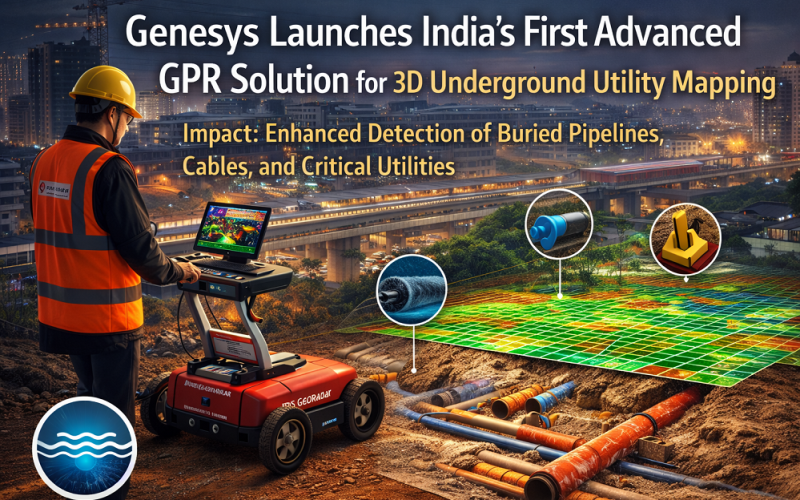
Mumbai-based geospatial firm Genesys International Corporation Ltd has officially launched India’s first advanced Ground Penetrating Radar (GPR) solution from IDS GeoRadar for high-resolution 3D underground utility mapping. Announced on 6 March 2026, the system will enable Indian cities, metro authorities, and infrastructure agencies to precisely detect and map buried pipelines, cables, and other critical utilities — dramatically reducing excavation risk across smart city and infrastructure projects.
Background
India’s rapid urban expansion — driven by metro rail construction, smart city programmes, highway development, and water infrastructure modernisation — has created urgent demand for reliable subsurface geospatial intelligence. Many cities lack accurate, unified records of what lies beneath their streets, resulting in accidental damage to buried utilities during construction, costly project delays, and safety hazards. Genesys International, which operates a team of over 2,000 professionals and maintains a nationwide sensor network, has established itself as a leading provider of high-accuracy mapping, 3D
Technology and Methodology: 3D Underground Utility Mapping with GPR
The system is powered by two proprietary technologies: Equalised Scrambling Technology (EST) and Wide/Multi Array Antenna Technology. EST reduces the noise floor in subsurface radar reflections by scrambling and equalising transmitted pulses, enabling discrimination of closely-spaced utility lines even at depth. The multi-array antenna configuration simultaneously illuminates multiple subsurface planes, generating a full 3D point cloud of buried infrastructure in a single pass rather than requiring multiple overlapping transects.
The GPR transmits electromagnetic pulses into the ground and records reflection travel times from interfaces between materials of differing dielectric constants — for example, the boundary between soil and a water-filled pipe, or between concrete and an empty conduit. Collected waveforms are processed into B-scan cross-sections and then interpolated into volumetric 3D subsurface models. Genesys plans to integrate the IDS GeoRadar outputs with its existing digital mapping and 3D geospatial platforms, enabling the creation of subsurface digital twins that represent underground infrastructure alongside surface city models. These digital twins will allow city authorities to visualise, monitor, and manage below-ground assets in a single unified platform.
Also Read – Subsurface Intelligence Mapping: Genesys Launches India’s First 3D Survey of Adani Airport
Implementation and Study Area
The technology is targeted at India’s rapidly growing urban centres, particularly cities engaged in metro rail expansion, National Highway Authority of India (NHAI) corridor upgrades, and water network rehabilitation under the Atal Mission for Rejuvenation and Urban Transformation (AMRUT 2.0). Initial deployments are expected in tier-1 cities, with the system positioned to support both greenfield infrastructure surveys ahead of construction and asset verification surveys of existing buried utility networks where historical records are incomplete or outdated. Genesys received a major project contract worth ₹127.8 million in January 2026, signalling strong pipeline demand for advanced geospatial services.
Applications and Impact
The deployment of advanced GPR-based 3D utility mapping delivers measurable benefits across several domains:
- Smart city development: creation of accurate subsurface GIS layers for city digital twins
- Construction safety: reducing accidental utility strikes during excavation
- Infrastructure resilience: identifying at-risk buried water mains before failure
- Utility coordination: enabling multiple agencies sharing the same corridor to work from a single georeferenced dataset
Conclusion
The introduction of IDS GeoRadar’s Ground Penetrating Radar system by Genesys International marks a milestone in India’s geospatial infrastructure capability. As urban India accelerates its infrastructure agenda, the ability to build reliable subsurface digital twins will become a core requirement for safe, efficient, and sustainable city development. This launch signals a maturing of the geospatial mapping sector in India — one capable of delivering world-class underground intelligence at national scale.
References
1. Genesys International Corporation Ltd (2026). Press release: Launch of IDS GeoRadar GPR System. March 6, 2026. CXO Today / Manufacturing Today India.
2. Machine Maker (2026). Genesys International Corporation Ltd Introduces Advanced IDS GeoRadar GPR System. themachinemaker.com
3. Autocar Professional (2026). Genesys Launches Ground-Penetrating Radar System for Underground Utility Mapping in India. autocarpro.in
4. Angel One (2026). Genesys International Shares Jumps Over 4%; Introduces IDS GeoRadar Technology. angelone.in