Navitel Navigator Releases Q1 2014 Update of Maps of Europe, Central Asia, Russia and Turkey

 Q1 2014 update of NAVITEL® maps of Europe, Central Asia, Russia and Turkey announced!
The users of Navitel Navigator can update maps of Europe, Central Asia, Russia and Turkey up to the Q1 2014 version.
The Q1 2014 update concerns such countries as Albania, Andorra, Armenia, Austria, Azerbaijan, Belarus, Belgium, Bosnia and Herzegovina, Bulgaria, Croatia, Cyprus, Czech Republic, Denmark, Estonia, Finland, France, Georgia, Germany, Gibraltar, Greece, Hungary, Italy, Kazakhstan, Kyrgyzstan, Latvia, Liechtenstein, Lithuania, Luxembourg, Macedonia, Malta, Moldova, Monaco, Montenegro, Netherlands, Norway, Poland, Portugal, Romania, Russia, San Marino, Serbia, Slovakia, Slovenia, Spain, Sweden, Switzerland, Tajikistan, Turkey, Ukraine, Uzbekistan, Vatican City State.
The maps of the new version contain 15 517 759 km of road graph, 6 403 514 POI, 863 139 cities, towns and other settlements, with address search option and road network display available for 225 525 of them.
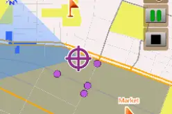
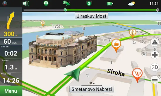
Visual representation of road networks, traffic jams and routes is now even better than before. Address data have been specified in the new maps, as well as information on some prohibited turnsupdated! 3D models of more than 70 objects have been added!
Czech Republic
The map of Czech Republic contains 20 535 cities, towns and other settlements, with address search option and road network display available for 8 355 of them.
Point of Interest database has been increased and updated, including now the total of 64 997 POI. Total length of the road graph is 144 433 km.
 New 3D models added:
Prague: City Empiria, City Tower, Corinthia hotel, Hlavní nádraží, Staroměstská mostecká věž, Malostranské mostecké věž, Národní divadlo, Pálac Kinských, Petřínská rozhledna, Rudolfínum, Tančící dům, Národní památník na Vítkově, Žižkovská věž.
Brno: Katedrála sv. Petra a Pavla, Hrad Špilberk.
Karlovy Vary: Vřídelní kolonáda.
Karlštejn: Hrad Karlštejn.
Lednice: Minaret (Lednicko-valtický areál).
Olomouc: Katedrála sv. Václava.
Plzeň: Brána Plzeňského Prazdroje, Plzeňská radnice, Velká synagoga.
Poland
The map of Poland contains 62 290 cities, towns and other settlements, with address search option and road network display available for 6 804 of them.
Point of Interest database has been increased and updated, including now the total of 224 357 POI. Total length of the road graph is 691 356 km.
New 3D models added:
Warsaw: Arkadia, Babka Tower, Barbakan, Biurowiec TP SA, Blok Mieszklany, Blue City, Centrum Systemów Telekomunikacyjnych, Dom Studencki “Riviera”, Dworzec PKP Warszawa Centralna, Hotel Hilton, Hotel InterContinental, Hotel Marriott, Hotel Novotel, Ilmet, Kancelaria Prezesa Rady Ministrów, Łucka City, Millennium Plaza, ORCO Tower, Oxford Tower, Pałac Kultury i Nauki, Pałac Prezydencki, Pekao Tower, Punktowiec, Rondo 1, Kancelaria Sejmu RP, Sienna Center, Teatr Narodowy, Warsaw Financial Center, Warsaw Trade Tower, Warta Tower, Wola Park, Zamek Królewski, Złote Tarasy.
The road sections of A4 motorway (such as “Debica-Rzeszow” and “Krakow-Tarnow”) were added to the map. It has a significant effect on the traffic management.
Germany
The map of Germany contains 64 625 cities, towns and other settlements, with address search option and road network display available for 15 489 of them. Point of Interest database has been increased and updated, including now the total of 1 629 520 POI. Total length of the road graph is 1 153 886 km.
All the maps include residential and industrial areas, allowing address search, detailed representation of streets and roads and taking into account road directions, interchanges, roundabouts and other important road information.
To learn more details about maps, please, visit the “Coverage” section of the http://navitel.cz/en/coverage/ website.
IMPORTANT! Please, note that the Q1 2014 maps are compatible only with 8.0 and later versions of Navitel Navigator software.