New add-in connects NavVis reality capture to BIM models in Autodesk Revit
MUNICH, Germany, 25 April 2018 – NavVis, a global leader in mobile indoor mapping, visualization, and navigation, announces a new add-in for Autodesk Revit. The add-in lets Revit users connect their BIM models to 360 degree immersive imagery and point clouds captured by the NavVis mobile mapping system. This add-in simplifies the process of creating and updating outdated BIM models to reflect the current state of the building.
NavVis technology is an all-in-one reality capture solution that has made it possible to quickly scan the current state of large industrial and commercial properties and stream the data on any device. The data is captured by the NavVis M6 mobile mapping system, an innovative mobile mapping system that can scan indoor environments at the speed of walking. The data is then visualized in the NavVis IndoorViewer, which is browser-based software that streams the immersive panoramic images and point clouds.
NavVis IndoorViewer Add-In visualizes buildings in Autodesk Revit
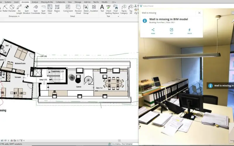
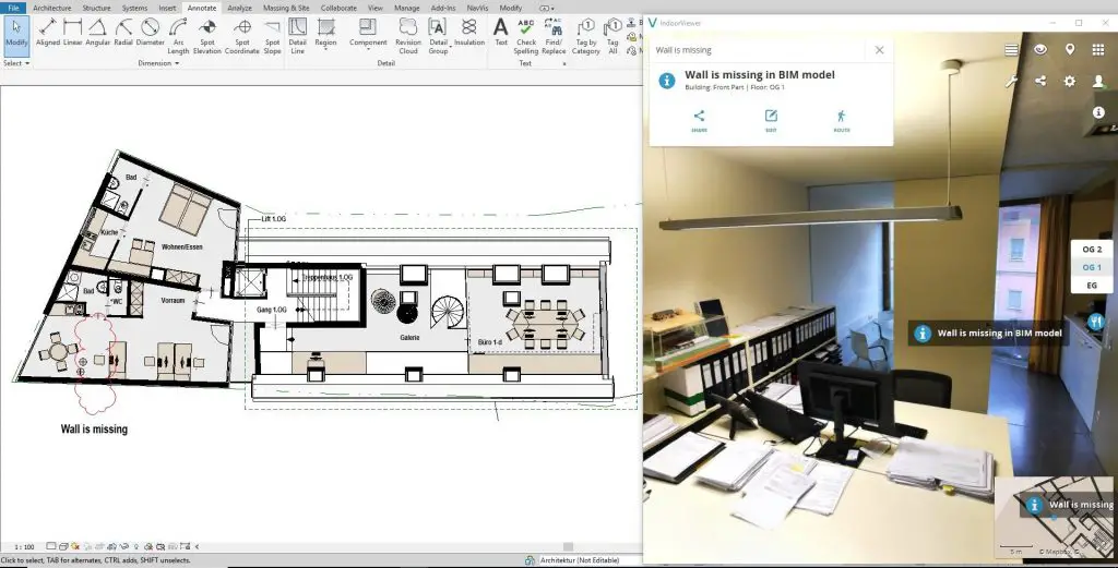
With the Revit add-in, the NavVis IndoorViewer can now easily be integrated with Revit BIM models. Integrating Revit and IndoorViewer allows for a side-by-side comparison of the BIM model and the scanned state of the building, remotely from a desktop. This lets users quickly spot the changes that have been made since the model was created and the current state was captured, helping to speed up the process of updating BIM models. Integrating BIM and IndoorViewer also overcomes data silos and reduces planning errors that occur as a result of outdated information.
Revit users who install the add-in will be able to access the added value of the NavVis IndoorViewer, which includes adding and searching for information and mark-ups, taking measurements, route finding and online collaboration with stakeholders.
For more information visit: www.navvis.com/revit
Dr. Felix Reinshagen, CEO of NavVis, said:
“I am very excited to announce that NavVis users can now directly integrate Revit BIM models with our browser-based IndoorViewer. Connecting BIM and reality capture significantly reduces the time and cost of updating as-planned models to reflect the current state of the building. With this new add-in, we have been able to provide a seamless workflow between NavVis and Autodesk Revit.”
Gary Wyatt, Director of industry strategy for building design at Autodesk, said:
“Autodesk is pleased to partner with NavVis on their new Revit extension, connecting Revit to their innovative indoor mapping solution. NavVis facilitates interconnected workflows by enabling Revit customers to more easily create and maintain accurate BIM models of existing buildings.”
Autodesk Revit is available as a standalone product or as part of Autodesk’s AEC Collection.
Find the App at https://apps.autodesk.com/RVT/en/Detail/Index?id=5489279304951773635&appLang=en&os=Win64&mode=preview
Watch the video at https://youtu.be/F02wns-ZhNA
For more information, please contact:
| Munich Office: | T: (+49) 89 7169 250 20 |
| Viktoria Langley | E: press@navvis.com |
| New York Office: | T: (+1) (646) 714-7016 |
| Evan McPhee | E: press@navvis.com |
About NavVis:
NavVis is a leading provider of high-end digital building technology for large commercial and industrial properties. Our cutting edge indoor mapping, visualization and navigation technology is being applied in every industry that uses, manages or builds indoor space. Digital building technology is benefitting everything from construction monitoring, facility management, and manufacturing, to transportation hubs and multi-channel retailing.