21 PhotoSat surveying accuracy studies from seven different stereo satellites
PhotoSat has published 21 new satellite surveying and mapping accuracy studies, now available on our website. The studies include data from seven different stereo satellite systems. The best results show elevation surveying accuracies of better than 15cm.
The accuracy studies include stereo satellite data from the following satellites:
- WorldView-1
- WorldView-2
- WorldView-3
- Pleiades-1B
- KOMPSAT-3A
- SPOT-7
- ALOS PRISM
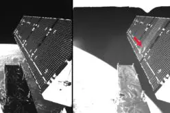
3D WorldView-2 satellite photo of Asmara, Eritrea, showing some of the 775 ground survey points that determine the 14cm PhotoSat surveying accuracy.
PhotoSat has measured accuracy on over 700 stereo satellite surveying projects
PhotoSat has delivered over 700 satellite surveying projects since 2007 and we have carried out accuracy evaluations on the majority of them. Most of the survey data on these projects belongs to our customers and cannot be shared publically; however, customers have provided feedback on many of these projects.
The results of these 21 new accuracy studies are consistent with our project accuracy evaluations and customer feedback.
PhotoSat accuracy test areas in Eritrea and California
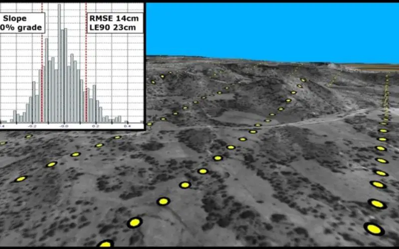
The accuracy studies were conducted over two test areas. One test area is west of Asmara, Eritrea where PhotoSat has access to more than 45,000 ground survey points over a 50km by 20km block.
The second area is in SE California where PhotoSat uses a very accurate Opentopography.org open source LiDAR survey.
The effect of different numbers of ground survey points
The studies employed different numbers of ground survey control points for each test area and each satellite system. For some of the satellite stereo pairs the accuracy is significantly improved by increasing the number of ground survey control points.
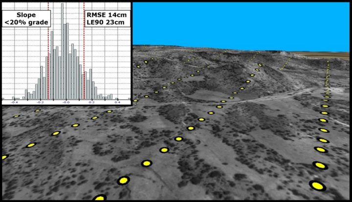
For example, the WorldView-2 survey for Eritrea is accurate to 19cm in elevation with two ground control survey points, and accurate to 14cm in elevation with 21 ground control points.
In contrast, the accuracy of the WorldView-3 survey for the California test area is not improved by additional ground survey points. This WorldView-3 survey is accurate to 13cm in elevation with one ground survey control point and with 153 ground survey control points.
PhotoSat has been continuously producing satellite accuracy studies since 2007
In order to provide objective quantifiable accuracy data for stereo satellite surveying and mapping, PhotoSat has been continuously producing accuracy studies since 2007. We have previously published nine of these studies. The rest of the studies were used for calibrating and improving our processes.
21 new accuracy studies all processed with the same version of the PhotoSat processing system
The 21 new accuracy studies were produced with the most recent version (2016) of the PhotoSat processing system. Where possible we used satellite data produced by the 2015 or 2016 versions of the satellite operators’ ground processing systems.
Summary of PhotoSat 2016 accuracy study results
| Satellite | Test area | km² | GCP | RMSE |
|---|---|---|---|---|
| WorldView-3 | California | 150 | 1 | 13cm |
| WorldView-3 | California | 146 | 153 | 13cm |
| WorldView-3 | Eritrea | 100 | 21 | 15cm |
| WorldView-2 | California | 173 | 1 | 15cm |
| WorldView-2 | California | 173 | 153 | 12cm |
| WorldView-2 | Eritrea | 100 | 21 | 14cm |
| WorldView-1 | California | 174 | 153 | 14cm |
| WorldView-3 | Eritrea | 198 | 2 | 19cm |
| WorldView-2 | Eritrea | 400 | 2 | 19cm |
| WorldView-1 | Eritrea | 100 | 21 | 19cm |
| WorldView-1 | California | 174 | 1 | 23cm |
| WorldView-1 | Eritrea | 420 | 9 | 23cm |
| Kompsat-3A | California | 144 | 14 | 21cm |
| Pleiades-1B | Eritrea | 189 | 74 | 26cm |
| Pleiades-1B | Eritrea | 189 | 1 | 28cm |
| Kompsat-3A | California | 144 | 1 | 50cm |
| Kompsat-3A | Eritrea | 130 | 11 | 48cm |
| Kompsat-3A | Eritrea | 130 | 1 | 53cm |
| SPOT 7 | Eritrea | 1,458 | 1 | 4m |
| ALOS PRISM | Eritrea | 2,300 | 3 | 2m |
| ALOS PRISM | Eritrea | 2,300 | 1 | 4m |
See PhotoSat’s accuracy studies overview for full details.