NORTH ADAMS, Massachusetts, 4 October 2017 – Col-East International Ltd., a provider of aerial photogrammetric services in the Northeast U.S. since 1952, tapped into its extensive archive of aerial imagery to create hybrid topographic maps of an area of Marshfield, Mass. The map products contained data from spring and summer image acquisitions as well as fieldwork to satisfy the diverse requirements of multiple planned applications.
“We extracted topography from low-tide 2010 spring air photos and merged it with field-surveyed elevations and topography extracted from a new summer flight to generate a hybrid map,” said Shaun Vincent, Col-East Project Manager.
Marshfield is located on Boston’s South Shore near Cape Cod. Stenbeck & Taylor, Inc., the local firm providing engineering services to Marshfield, requested new mapping to support a variety of applications including property surveys, utility infrastructure siting and flood analysis. The town’s beachfront Esplanade needed detailed topography for infrastructure and boundary work. Dotted with numerous wetlands, Marshfield needed elevations of the flood gate culverts and channels flowing through its marshes to calculate storm surge capacities as part of hurricane preparedness work.
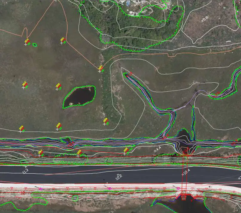
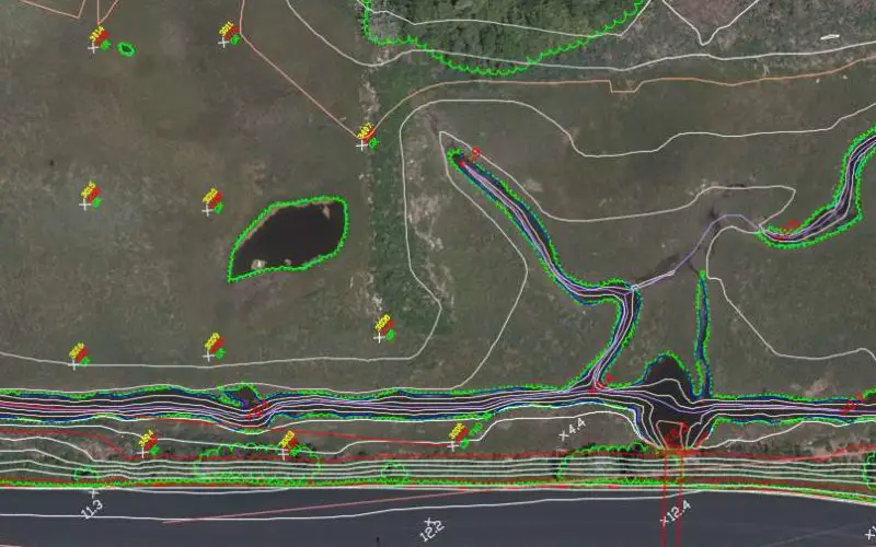
New summer UltraCam Eagle photography was used in conjunction with spring 2010 film and field survey data to create a new topographic survey in Marshfield, MA.
Col-East received the request for topographic contours and other mapping products in early summer 2017. By then, however, marsh grasses and other vegetation obscured the banks and channels of the rivers, making accurate contour mapping from aerial imagery nearly impossible there. New image acquisition wasn’t an ideal option due to the vegetation, and while seven-year-old archived leaf-off air photos were available for channel mapping, they lacked the timeliness to satisfy Marshfield’s other needs.
“Thanks to our unmatched aerial archive and new Vexcel UltraCam Eagle, we were able to satisfy Marshfield’s diverse needs by fusing information from two data sets – and we did it on a tight schedule,” said Vincent.
On the next clear day, Col-East captured 5-centimeter color imagery with the UltraCam Eagle, using minimal ground survey control due to the quality of the onboard GPS. Back on the ground, the Col-East photogrammetry team generated topographic maps at a scale of 1”=40’ with one-foot contours from the new imagery. As expected though, the marsh grasses and high tide stymied contour extraction from much of the wetland area.
The photogrammetrists turned to the Col-East archive, which contains more than 400,000 analog and digital images of Massachusetts, New York, Rhode Island, Connecticut, New Hampshire, and Maine. Several excellent low-tide spring air photos captured with a film camera in 2010 was procured from the archive. Stenbeck & Taylor supplied field topo measurements and Col-East’s photogrammetrists extracted terrain data to supplement the topography in the obscured areas. This hybrid dataset was then also used to generate orthoimagery from the new Eagle photography.
Less than a month after the initial request, Col-East delivered the new orthoimagery and hybrid contour maps to Stenbeck & Taylor for their storm surge, boundary, utility and infrastructure work.
“The mapping collected by Col-East matched our field measurements very well and was a cost-effective way to update the Marshfield site for multiple projects,” said Brian Taylor, president of Stenbeck & Taylor Inc.
About Col-East International Ltd. (www.col-east.com)
Based in North Adams, Mass., Col-East has been providing quality aerial photography and photogrammetric services to clients in the Northeast United States from Maine to New Jersey since 1952. Col-East derives orthoimagery, 3D terrain models, topographic maps and 3D building models from the airborne imagery and LiDAR it collects and delivers end products in a variety of GIS and CAD formats.
In early 2017, Col-East was acquired by Bluesky International, an aerial mapping innovator based in the United Kingdom. Bluesky specializes in acquiring aerial photography, LiDAR and thermal data using the very latest survey technology. Bluesky is leading the way in developing innovative solutions for environmental applications, including the UK’s first National Tree Map (NTM), solar mapping and citywide ‘heat loss’ maps and is currently developing noise and air quality mapping products. www.bluesky-world.com.
Contacts
Mark Thaisz
Email: mthaisz@col-east.com
Direct Tel: 800-359-8676 x208
Col-East, Inc.
P.O. Box 347
Harriman & West Airport
North Adams, Massachusetts 01247
800-FLY-TOPO (359-8676)
www.bluesky-world.com
www.col-east.com