
Tag "Britain"

Britain to Utilize Location Data to Support EV Charging Points
Location data is a key component of the EV charging process. The use of location data to support EV charging points or electric vehicle chargers is a key part of
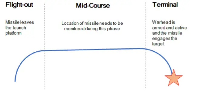
Britain Seeks Alternative for Satellite Navigation
With so many advancements in satellite navigation systems, satellite navigation has become fundamental to the functioning of society in the last few decades. Satellite navigation has become more familiar, whether
UK Announces New Geospatial Commission
Chancellor announces new Geospatial Commission to maximise the value of all UK government data linked to location. UK – November 22, 2017 – The Chancellor has announced today a new Geospatial

Geovation Challenge: Turn Your Great Idea into a Great Business
If you’re a UK start-up and want to help solve pressing issues using location information; the Challenge could be perfect for you. You might be an innovator with a passion for
Bluesky Tree Map of Britain Used to Create First High Res Maps of Allergenic Pollen-Producing Plants
A map of over 280 million trees nationwide has been used to create the first high resolution maps of allergenic plants and trees of Great Britain. Detailing the location of

UK Leading the Way to a 5G Future
World first initiative will lay groundwork for a hyper-connected Britain. Ordnance Survey to create UK’s digital twin – a smart map for a smart future. Project will cement UK’s position as
Is Britain on the move?
Australia has recently announced a 1.8m shift in its mapping coordinates, to compensate for the country’s 7.5cm shift north each year. Inevitably the question is why, and could the same

Ordnance Survey Encourages People to Use Up-To-Date Maps with Their Trade-In Scheme
Outdoors enthusiasts can build impressive collections of Ordnance Survey maps, but it often means they’re not using the most up-to-date maps to get outside and explore Britain. Up until 20 March,
