
Tag "Disaster Risk Reduction"

Calling Innovators: Be Part of ISRO Immersion Startup Challenge Today!
Are you ready to ignite the future of space exploration? The ISRO Immersion Startup Challenge is a one-day event designed to spark innovation, build connections, and empower the next generation
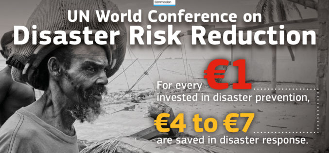
Sendai Framework for Disaster Risk Reduction
The Sendai Framework for Disaster Risk Reduction 2015-2030 provides a new global approach to disaster risk management policy and operations. In June 2016, the European Commission published an action plan

Odisha Goes for Flood Mapping
According to recent news by The New Indian Express, the Odisha State Disaster Mitigation Authority (OSDMA) has released a Flood Inundation Mapping (FIM) for Kendrapara, a coastal district of Odisha.
UN Certificate Course on Geospatial Technologies for Disaster Risk Reduction
Geospatial Technologies for Disaster Risk Reduction in the Horn of Africa Geographic information systems (GIS) can be a very useful tool for the whole disaster management cycle starting from the
