
Tag "GeoNews"
UK Announces New Geospatial Commission
Chancellor announces new Geospatial Commission to maximise the value of all UK government data linked to location. UK – November 22, 2017 – The Chancellor has announced today a new Geospatial

IIC Technologies Earns CMMI Level 3 Appraisal
IIC Technologies, has further strengthened its position as one of the reliable and efficient geospatial software solutions and service provider, by being appraised at CMMI maturity level 3. Both waterfall
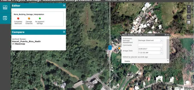
Esri Provides Mapping Technology for Students to Assess Hurricane Damage
Schools Can Use High-Resolution Imagery to Identify Where Help Is Needed to Rebuild in Puerto Rico November 9, 2017, Redlands, California – Esri, the world leader in spatial analytics, today announced it

Woolpert Contracted for $1.7M University Field House
The firm was contracted by Mecklenburg County to design this shared facility that will benefit both county residents and students at Queens University. CHARLOTTE, N.C. (Nov. 3, 2017) — Woolpert

Velodyne LiDAR Partners with YellowScan for Integrated LiDAR for UAVs
YellowScan to leverage Velodyne’s lightweight VLP-16 Puck LiDAR sensors for its advanced aerial Surveyor LiDAR system October 26, 2017 – SAN JOSE, Calif.–(BUSINESS WIRE)–Velodyne LiDAR Inc., the world leader in 3D

Goa-based Transerve Technologies Raises $1.6mn Funds
Panji, Goa – According to recent news by the TOI and SMEPost.com, Goa-based Transerve Technologies, a company that offers geospatial technology-based SaaS solutions for sustainable growth and urban planning, has raised

Reliance Energy Launches App for Complaints on Defective Street Lights
September 28, 2017, Mumbai – (IANS) – In an effort to make Mumbai streets safer after dark, Reliance Energy has launched a new app-based service for lodging complaints on defective street lights,

DLR-JAXA Joint Statement Concerning the Bilateral Cooperation
September 20, 2017 – Japan Aerospace Exploration Agency (JAXA) and the German Aerospace Center (Deutsches Zentrum für Luft- und Raumfahrt; DLR) held the Inter-Agency Meeting to strengthen and deepen the
New Airbus Aerial Technology Impacts Hurricane Irma Recovery Efforts
September 12, 2017 – As residents and insurers in the southeastern United States begin to consider recovery efforts following Hurricane Irma, Airbus Aerial is prepared to help by providing insurance

OGC Approves Community Standard for Streaming 3D Content
September 06, 2017 – The Open Geospatial Consortium (OGC®) membership has approved a new 3D standard for content strategy. This standard is focused on high performance visualization and spatial analysis
