
Tag "GeoNews"

Pix4D Among UAV Industry Leaders Intel® Uses to Launch Intel Insights Platform
September 7, 2017 – Yesterday at InterDrone, Intel CEO Brian Krzanich announced the new Intel Insight Platform that will allow select enterprise customers to accelerate the path from drone flight to

Honeywell Launches UAV Industrial Inspection Service, Teams With Intel On Innovative Offering
MORRIS PLAINS, N.J., Sept. 6, 2017 /PRNewswire/ — Honeywell (NYSE: HON) has launched its first commercial unmanned aerial vehicle (UAV) inspection service, the Honeywell InView inspection service, to help industrial

OGC Seeks Public Comment on Proposed Geocoding API Standards Working Group
September 5, 2017 – The Open Geospatial Consortium (OGC®) is requesting comments on the draft charter for an OGC Geocoding API Standards Working Group (SWG). Geocoding is the act of linking
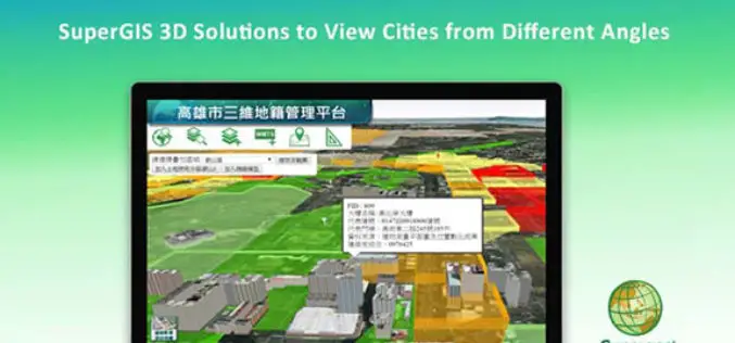
SuperGIS 3D Solutions to View Cities from Different Angles
In recent years, with the progress of information technology and hardware, many organizations are seeking to use advanced 3D tech to display their spatial data. Conforming to this trend, Supergeo,

DigitalGlobe Delivers WorldView-4 High-Resolution Satellite Imagery to Power PSMA Australia’s Continent-scale Mapping Initiative
WorldView-4 Imagery To Become Available To All Commercial Customers On August 31 WESTMINSTER, Colo.–(BUSINESS WIRE)–Aug. 29, 2017– DigitalGlobe, Inc. (NYSE: DGI), the global leader in Earth imagery and information about our changing planet,
Boundless Donates $100,000 to LaunchCode in Support of CoderGirl Education Program
Donation Will Be Used to Support and Expand Program Throughout the St. Louis Area NEW YORK – August 29, 2017 – Boundless, the leader in open GIS, today announced that it

China, Russia to Sign Agreement to Boost Space Cooperation
Beijing, Aug 28 (IANS): China and Russia are set to sign a milestone agreement on joint space exploration from 2018 to 2022, the media reported on Monday. The deal is expected

Malaysian Geospatial Master Plan to be Completed in 2018
August 22, 2017 – Putrajaya, Malaysia: The Natural Resources and Environment Ministry (NRE) is developing the National Geospatial Master Plan (NGMP) towards realising the potential of geospatial technology, in line with the
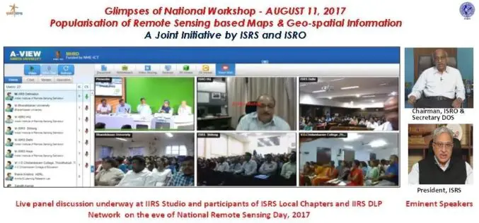
National Workshop on Popularisation of Remote Sensing Based Maps and Geo-spatial Information
August 22, 2017 – A National Workshop on Popularisation of Remote Sensing Based Maps and Geo-spatial Information was organised jointly by ISRS and ISRO on the eve of National Remote Sensing
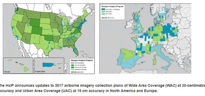
Hexagon Imagery Program Announces Updates to 2017 Airborne Imagery Collection Plans
Latest imagery collection covers U.S., Canada, Europe, plans include territories, cities (WASHINGTON, D.C., Aug. 15, 2017) – The Hexagon Imagery Program (HxIP), the premier source for professional airborne imagery provided
