
Researchers at the University of Missouri are pioneering the integration of light detection and ranging (LiDAR) technology with artificial intelligence (AI) to enhance transportation safety, focusing on the interactions among pedestrians, cyclists, and vehicles at traffic signals. This innovative approach aims to provide deeper insights into traffic dynamics, ultimately reducing accidents and improving overall road safety.
LiDAR technology utilizes lasers to create detailed three-dimensional representations of environments, accurately measuring distances and speeds of various objects, including vehicles and pedestrians. By combining LiDAR data with AI algorithms, the research team can analyze complex traffic scenarios, which is crucial for enhancing driver awareness and reducing accidents, especially as autonomous vehicles become more prevalent.
“By having a better understanding of how pedestrians and cyclists interact with each other on the roads, this study will help us design advanced systems that will allow vehicles to better understand and avoid other road users,” said Associate Professor Yaw Adu-Gyamfi. “This is important especially as autonomous vehicles become more common.”
Also Read – LiDAR in Traffic Management: UDOT’s Plan for Safer Intersections
The innovative approach addresses a significant gap in industry data concerning the dynamics at traffic signals involving cyclists, pedestrians, and vehicles. The insights gained can inform the design of advanced vehicular systems capable of anticipating and mitigating potential conflicts with vulnerable road users.
In practical terms, this technology can identify near-miss incidents between vehicles and pedestrians, providing valuable data to prevent future accidents. As the system becomes more widespread, it could monitor how individuals and vehicles approach intersections, sharing this information with connected vehicles to enhance safety measures.
“This approach would require working with car manufacturers to build the technology into vehicles,” Adu-Gyamfi noted. “In fact, some cars already connect with traffic systems using networks like cellular vehicle-to-everything (C-V2X).”
Beyond improving intersection safety, the data collected can assist transportation experts in optimizing pedestrian crossing times, monitoring vehicle behavior in work zones to detect speeding or distracted driving, and identifying infrastructure issues such as potholes.
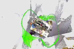
For their study, the researchers deployed a combined camera and LiDAR system at an intersection to observe traffic patterns. They innovated by optimizing the technology to function effectively with a single LiDAR unit, as opposed to the conventional dual-unit setup. Additionally, by applying a technique known as point cloud completion, they enhanced the detection and classification accuracy of various objects, including buses, pedestrians, and cyclists.
“Instead of retraining a machine learning model to detect objects, we used a pre-trained one and created a new algorithm to estimate an object’s height and width,” Adu-Gyamfi explained. “This helped us classify objects more accurately than other AI models designed for the same task.”
While the results are promising, the researchers acknowledge that further work is necessary before this technology can be widely implemented on roads and highways. Challenges such as system scalability, integration with existing traffic infrastructure, and collaboration with automotive manufacturers need to be addressed to fully realize the potential of this innovative approach to transportation safety.
Source: University of Missouri