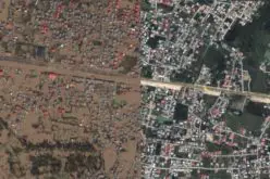

Image: US Army Geospatial Intelligence Analyst Course students and instructors tour the DCGS-A ground terminal station at the Joint Interoperability Test Command’s test site in US. Photo: courtesy of Mr Ray K.Ragan.
The US Army has developed a new geospatial analysis tool to help combatant commanders better plan their routes in unfamiliar locations.
Developed by the US Army Engineer Research and Development Center’s Geospatial Research Laboratory, the situational awareness geospatially enabled (SAGE) tool is designed to help increase the commanders’ understanding and knowledge of the impact of terrain and weather, leading to informed decisions.
Using four types of data, including elevation, terrain categorisation, roads / streets and map imagery, the tool aids intelligence analysts in rapid identification of the landscape and environments such as estimates of how quickly the enemy can march through a designated area due to the terrain.
7th Infantry Division, 2/2 Stryker Brigade Combat Team, 14th Brigade Engineer Battalion warrant officer 1 Robert Carle said: “SAGE truly cuts down the time required to create bulk products, allowing for more time to be spent conducting actual analysis.”
SAGE enables geospatial engineers, GEOINT professionals and analysts at various echelons, to create tactical decision aids in support of the military decision making process, intelligence preparation of the battlefield and soldier-leading procedures.
“SAGE truly cuts down the time required to create bulk products, allowing for more time to be spent conducting actual analysis.”
Currently used within the Distributed Common Ground System-Army (DCGS-A) worldwide, the tool successfully completed user-evaluation and validation surveys at the 10th Mountain Division (Light Infantry), 82nd Airborne Divison, US Marine Corps in Thailand, and the US military academy.
Also undertaken at US Army Japan, Fort Dix, New Jersey readiness and training facility, as well as the Joint Readiness Training Center at Fort Polk, Louisiana, US, the evaluations indicate a positive response to the SAGE programme from users, verifying its efficacy as a legitimate combat multiplier and solution to the legacy capability gap of taxing terrain analysis.
To date, SAGE has supported planning and operations at the Joint Readiness Training Center, the National Training Center and in Afghanistan.
Related Articles: