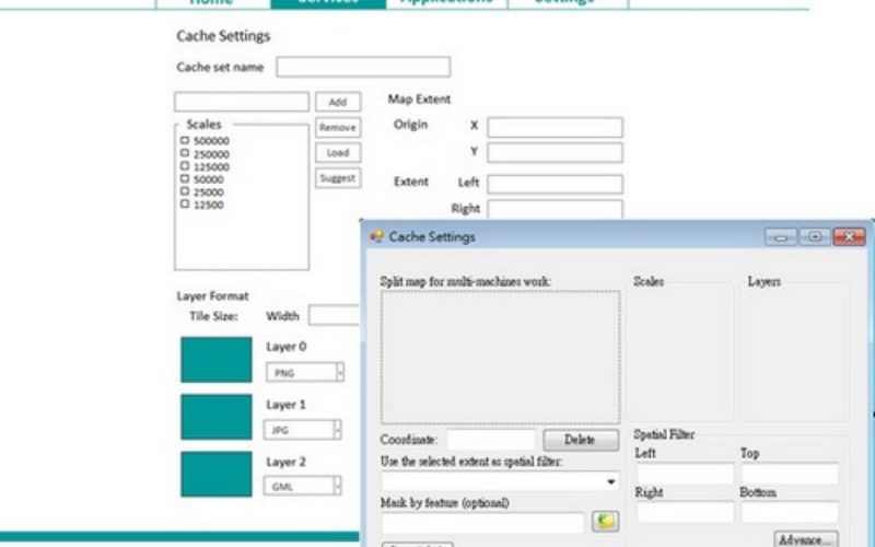
One of all GIS products that Supergeo Technology has been devoting to developing, implementing and promoting for the world, SuperGIS Desktop 10, is going to be launched for global users. As the next-generation desktop GIS, SuperGIS Desktop 10 is composed of considerate GIS functions and tools, leading to a constructive and across-the-board desktop GIS geographic information system providing new and splendid user experiences. In SuperGIS Desktop 10, there will be a major upgrade for Cache Generator, which supports vector tiles.
Vector tiles are chunked vector data which allows browsers or other client applications map geographic data faster. Although vector tiles are similar to raster tiles; yet instead of using map images, the data stored in each chunk are vector data, such as GeoJSON, protobuf, GML, and so on. Unlike raster tiles, the way how vector tiles are rendered can be changed and defined by users. They are basically raw shapefile or geofile that are chunked into tiles. Therefore, users will be able to use them to design symbology and perform geographical analyses.

Cache Generator uses GML as the format of vector tiles, which can be utilized by most of SuperGIS-series products, including SuperGIS Desktop, SuperGIS Globe, and SuperSurv, can be benefit to all GIS users for its latest technology in map tiles. Furthermore, it can be published through SuperGIS Server as well; meanwhile, its format can be transformed into GeoJSON, one of the commonly used vector tile formats nowadays. Therefore, it becomes possible to us to share vector tiles to other platforms like OpenStreetMap platform, or ArcGIS Online platform.
SuperGIS Desktop 10 will be release by this October. Now, feel free to download a free trial and try with Cache Generator workflows. Be the first one to get ready for the benefit of vector tiles!
Download SuperGIS Desktop 3.3 free trial: http://www.supergeotek.com/download_6_desktop.aspx
Get started with Cache Generator: https://www.youtube.com/watch?v=rfRIfYmgO6k