What is GNSS Reflectometry? How Does GNSS Reflectometry Work? Understanding Its Principles and Applications
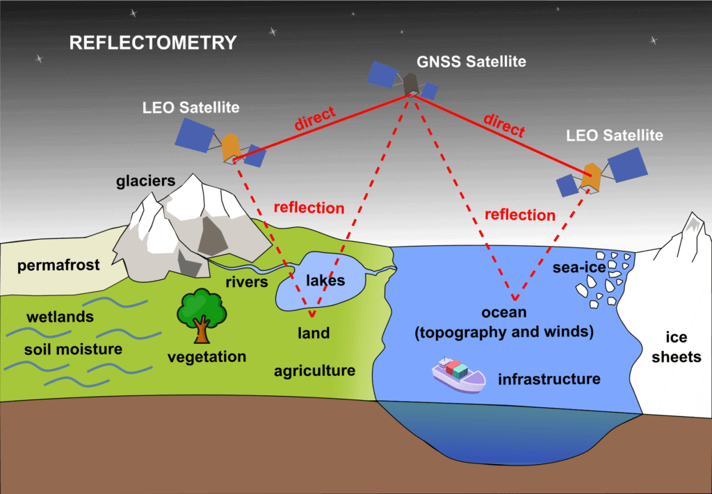
GNSS Reflectometry (GNSS-R) is an innovative remote sensing technique that leverages signals from Global Navigation Satellite Systems (GNSS) reflected off the Earth’s surface. Originally designed for navigation and geodetic applications, GNSS signals have now found a new purpose in environmental monitoring and Earth observation.
This technique has opened up a myriad of possibilities in monitoring various geophysical parameters, from ocean winds to soil moisture, offering a low-cost, scalable, and highly effective approach to remote sensing.
Background and Purpose of GNSS-R
The primary purpose of GNSS-R is to extract valuable environmental data by analyzing the reflected GNSS signals. Traditional remote sensing methods typically involve dedicated radar or optical sensors that actively transmit signals and then receive the backscattered signals from the Earth’s surface.
GNSS-R, however, utilizes existing GNSS signals, which are naturally transmitted by satellites like GPS or NavIC. This makes GNSS-R a resource-efficient technique, requiring only the receiver component, thereby reducing size, weight, power consumption, and cost.
Also Read – Understanding the Importance of L5 Frequency in GNSS
GNSS-R has proven useful in various applications, including monitoring ocean surface roughness, soil moisture, snow depth, vegetation growth, and even detecting natural hazards. The method gained traction after successful airborne experiments and spaceborne missions, such as the UK-DMC and TechDemoSat-1, which demonstrated the feasibility of GNSS-R for environmental monitoring.
How GNSS Reflectometry Works
The Principle of GNSS-R
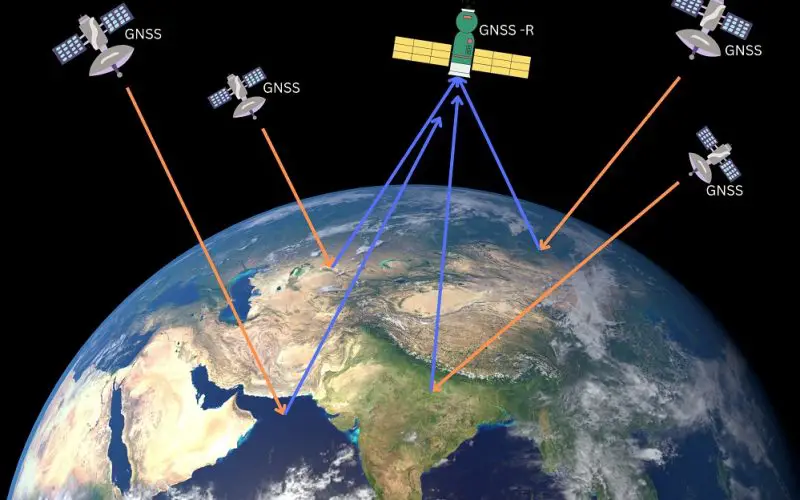
GNSS-R operates on the principle of receiving and analyzing signals that are reflected off the Earth’s surface. When a GNSS signal, initially intended for navigation purposes, hits the Earth’s surface, part of it is reflected into space. This reflected signal is captured by a receiver, either on the ground, airborne, or aboard a satellite.
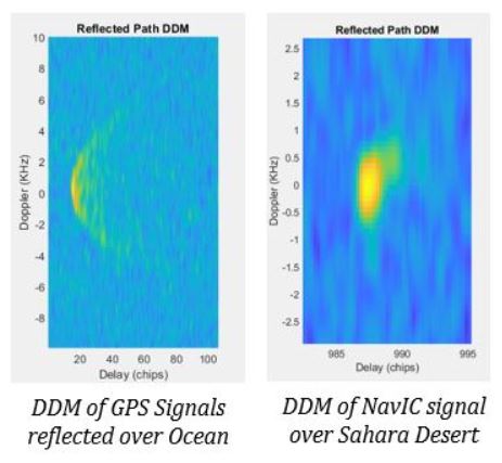
By cross-correlating the reflected signal with either a locally generated replica or the directly received signal, GNSS-R can produce Delay-Doppler Maps (DDMs). These DDMs provide critical information about the reflecting surface, such as surface roughness, moisture content, and more.
Conventional vs. Interferometric GNSS-R
The conventional GNSS-R (cGNSS-R) method involves cross-correlating the reflected signal with a locally generated replica to create DDMs. These maps reveal information about the surface’s reflective properties, such as ocean surface roughness and wind speed.
Interferometric GNSS-R (iGNSS-R), on the other hand, cross-correlates the reflected signal with the directly received GNSS signal, offering a more detailed analysis of the reflected signals. Both methods are being explored for various applications, including climate monitoring and natural hazard detection.
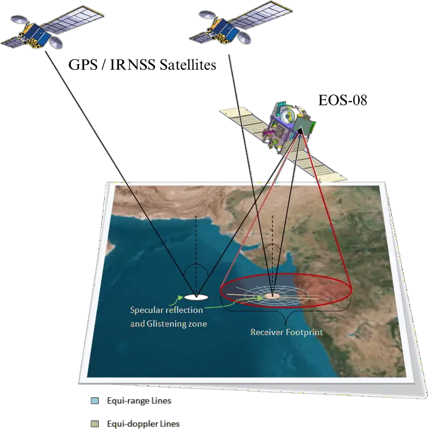
ISRO’s GNSS-R Instrument on EOS-08
The Indian Space Research Organisation (ISRO) has ventured into GNSS-R with the launch of the GNSS-R instrument aboard the EOS-08 satellite, which commenced operations on August 18, 2024. This instrument marks India’s first space-borne precision receiver for GNSS-R applications, focusing on collecting and analyzing reflected GNSS signals from various surfaces, including oceans, agricultural lands, and river bodies.
Data Collection and Processing
ISRO’s GNSS-R instrument collects raw data, which is processed at the National Remote Sensing Centre (NRSC) in Hyderabad. The data processing involves algorithms developed by the Space Applications Centre (SAC) in Ahmedabad, which generates multiple levels of data products.
The primary output, Dopper Delay Maps (DDMs), are used to derive scientific parameters such as reflectivity and Normalized Bistatic Radar Cross-Section (NBRCS). These parameters are crucial for retrieving information like soil moisture, surface inundation, and ocean surface wind and wave measurements.
Applications and Spatial Resolution
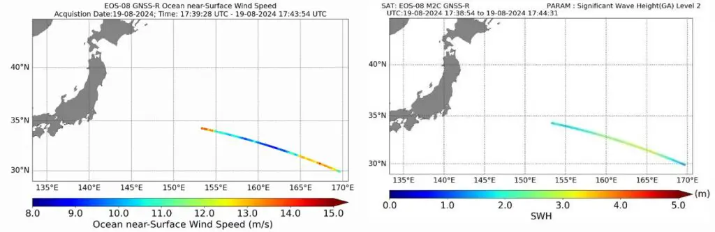
ISRO’s GNSS-R instrument provides a spatial resolution of 15 km x 15 km over oceans and better than 1 km x 1 km over land. This high resolution allows for detailed environmental monitoring, making it possible to track soil moisture in the Sahara Desert and surface inundation in the Amazon Rainforest. The first ocean data collected was processed to retrieve wind speed and significant wave height, demonstrating the instrument’s capability in oceanographic studies.
GNSS-R in Remote Sensing and Its Advantages
GNSS Reflectometry offers several advantages over traditional remote sensing techniques. Unlike conventional methods, which rely on dedicated signal transmitters and receivers, GNSS-R uses existing GNSS signals, making it a cost-effective solution. Additionally, GNSS-R can operate in various environmental conditions, as GNSS signals are less affected by atmospheric conditions like clouds or rain.
In remote sensing, GNSS-R is used to monitor a wide range of geophysical parameters, including soil moisture, sea level height, and vegetation state. Its ability to provide continuous, high-resolution data makes it an invaluable tool for environmental monitoring, climate studies, and disaster management.
How GNSS-R Differs from Traditional Remote Sensing
Traditional remote sensing techniques, such as radar and optical remote sensing, actively transmit signals and rely on the backscattered signals from the Earth’s surface. These methods are often resource-intensive, requiring high power, larger equipment, and more complex operations. GNSS-R, however, uses passive reflection of existing GNSS signals, requiring only a receiver, which is smaller, lighter, and consumes less power.
This passive nature of GNSS-R allows for more frequent data collection, especially when deployed on a constellation of satellites, offering faster coverage and more data for analysis.
Conclusion
GNSS Reflectometry represents a significant advancement in remote sensing, providing a resource-efficient, scalable, and versatile method for monitoring the Earth’s environment.
From ISRO’s pioneering efforts with EOS-08 to the broader applications across various geophysical parameters, GNSS-R is poised to play a central role in environmental monitoring and disaster management. As technology evolves, so too will the applications and capabilities of GNSS-R, offering even more detailed and timely insights into our planet’s dynamic systems.
If you found this article informative, don’t forget to comment, like, and share it with others interested in the future of remote sensing technology.