
Tag "ESRi"
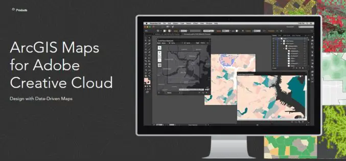
Esri Announce the Release of ArcGIS Maps for Adobe Creative Cloud!
The ArcGIS and Adobe® integration opens GIS up to an expanding group of design- and communications-focused users, who can now make direct use of spatial information. Cartographers can have the

Explore Places of Tourist Interest – Ajmer City
Contributed By:- Ajmer, located in the Ajmer District of Rajasthan is the 5th largest city of the state, and is located at a distance of 135 km from the capital

Varanasi the Spiritual Capital of India – a Journey Through Esri Story Map
Contributed By:- Varanasi (Kashi or Banaras) is a city in the northern Indian state of Uttar Pradesh dating to the 11th century B.C. Regarded as the spiritual capital of India,

Glimpse of The Dandi March Through Esri Story Map
The Salt March, also mainly known as the Salt Satyagraha, began with the Dandi March on 12 March 1930 and was an important part of the Indian independence movement. The

TerraGo Edge 4.0 Re-Imagines the User Experience, Adds New Mobile Features and Expands ESRI® ArcGIS® Integration Options
Using a customer-driven, agile feedback loop, TerraGo Edge undergoes a complete redesign, improves every aspect of the user experience to help get work done faster, easier and more efficiently than

mApp Your Way – Esri India App Development Challenge
mApp Your Way is an application (mobile or web) development challenge being organized by Esri India. The challenge intends to provide a platform to the institutes and students (UG/PG/Research scholars) to showcase

Avineon Announces Head Start Initiative for Esri Utility Network
McLean, Virginia – April 4, 2017 – Avineon, Inc., a successful provider of geospatial, information technology, and engineering support services for over 25 years, announces its Head Start initiative to

Esri Introduces Image Platform Bundles for Analysis, Management, and Analytics
Bundles Enable Organizations to Analyze Imagery in Minutes Instead of Hours Redlands, California—Esri, the global leader in spatial analytics, today introduced four image platform bundles that enable management and analytics

Vricon Announces Reseller Agreement with Esri
McLean, VA — March 3, 2017 — Vricon, a leading provider of highly accurate photorealistic 3D products and elevation data of the earth, today announced it has signed a reseller agreement with
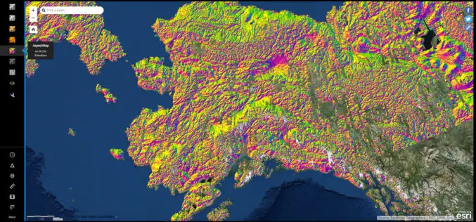
NGA Releases Biggest Collection of Arctic Elevation Data Yet at Esri FedGIS Conference
ArcticDEM Provides High-Quality Elevation Data and Enables Communities to Take Action Redlands, California—Esri, the global leader in spatial analytics, together with the ArcticDEM project—a public-private initiative to produce high-resolution, high-quality
