
Archive

Happy New Year – 2014
Happy New Year May you have a heart of courage a mind of will and may you get whatever you desire always at your will The phenomenon expressed as

UD Partners with Research Group for Sensors Curriculum
The University of Dayton is adding new curriculum for sensors and intelligence by partnering with a local research group. UD and Riverside Research will offer a new course, Fundamentals of Remote Sensing & Technical

PhD Position: Dynamics of land use change and the consequences on water and nutrient cycles
The Karlsruhe Institute of Technology (KIT) and its Institute of Meteorology and Climate Research/ Atmospheric Environmental Research (KIT/IMK-IFU) in Garmisch-Partenkirchen, Germany, invite applications to the open position of a Ph.D.

Pakistan to use Satellite imagery to remove encroachments
Digitalisation and satellite imaging of Islamabad would help eradicate encroachments in the city and also facilitate future planning by using latest technology and techniques as well as it will minimise

SuperGIS Desktop 3.1a Helps Civil Construction Work and Financing Projects in Lima, Peru
Supergeo Technologies, a leading global provider of complete GIS mapping software and solutions, announced that INVERMET, Peru, employed SuperGIS Desktop 3.1a to produce and manage integrated spatial data and analyses
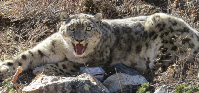
GPS Collaring to Protect Endangered Snow Leopard
Scientists in Nepal have taken a decisive step to save the endangered of snow leopard. Scientists are using satellite GPS technology for collaring of snow leopard. Snow leopard is
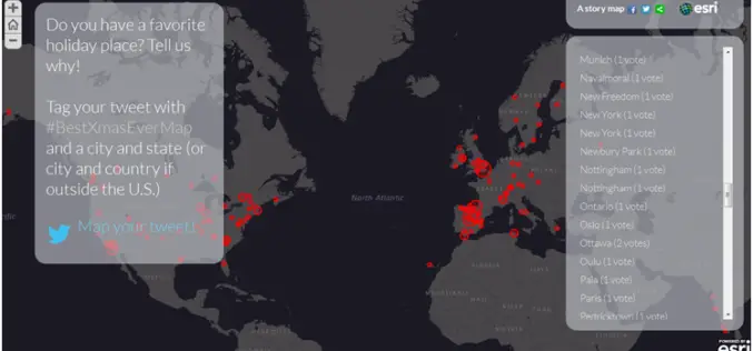
Discover Best Xmas Holidays Spot with Esri #BestXmasEver Map
Put your holiday tweet on the map with Esri Story Maps. Esri publishes story maps to showcase interesting and important topics for map-based storytelling and to help enable people to

GPS to Mark Wildlife Territory
The forest officials and ground staff at Bandipur, Naragahole and BRT Tiger Reserve have started a census to assess the number of carnivorous in these sanctuaries. Ground staff will be

Dubai Municipality Launches Makani an e-map App for Smart Phones
Geographic Information Systems Department of Dubai Municipality has released Makani, an e-map application for iPhone and Android phones. To make Makani a user-friendly for the residents of Dubai, the app is

Write a Remote Sensing Lesson and Win €5,000
European Space Agency is funding a competition with €5,000 as first prize for writing a remote sensing lesson Do you use Earth Observation data for teaching? Or do you
