 Digitalisation and satellite imaging of Islamabad would help eradicate encroachments in the city and also facilitate future planning by using latest technology and techniques as well as it will minimise the human involvement especially during the award of new sectors, said CDA Member (Administration) Amer Ali Ahmed.
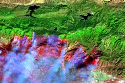
Capital Development Authority (CDA) will ink a Memorandum of Understanding (MoU) with Pakistan space and Upper Atmosphere Research Commission (Suparco) on Monday (December 16) regarding satellite imaging to root out encroachments from Islamabad by using overlay imaging technique. CDA Member (Administration) Amer Ali Ahmed will sign the MoU on behalf of CDA.
According to details this satellite imaging would be taken in four different phases. As a first step, Suparco would provide the data of satellite images of last five years, which is available with Suparco and by using overlay imaging technique CDA would be able to identify the encroachments during occurred during last five years said CDA Member (Administration) Amer Ali Ahmed.
Source: The News
Categories:
Remote Sensing
Tags:
Satellite imagery