
30 meter World Elevation Data is Now Available at JAXA’s Site Free of Charge!
The Japan Aerospace Exploration Agency (JAXA) will begin publishing free of charge an elevation data set that can express undulations of terrain over the world with a resolution of 30 meters horizontally (30-m mesh version, 1 arcsec). The data set has been compiled with images acquired by the Advanced Land Observing Satellite “DAICHI” (ALOS).
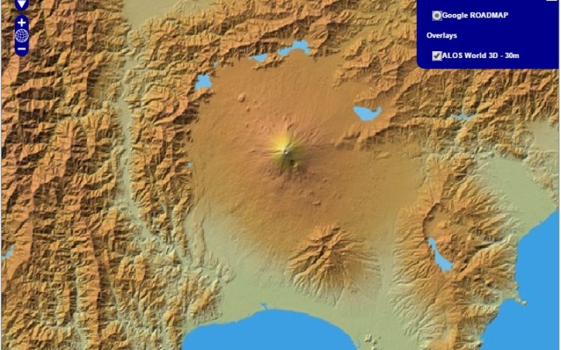
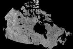
PRISM World Elevation Data (30-meter mesh version)
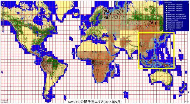
The yellow square indicates the area for the first publication.
Credit: JAXA
The Advanced Land Observing Satellite “DAICHI” (ALOS) has been developed to contribute to the fields of mapping, precise regional land coverage observation, disaster monitoring, and resource surveying. ALOS has three sensors: the Panchromatic Remote-sensing Instrument for Stereo Mapping (PRISM), the Advanced Visible and Near Infrared Radiometer type 2 (AVNIR-2) and the Phased Array type L-band Synthetic Aperture Radar (PALSAR).
As the first step, we will offer the areas in East Asia, including Japan, and South East Asia regions, and will expand the areas to all over the world (within 82 deg. of N/S latitudes).
The dataset is published based on the DSM dataset (5-meter mesh version) of the “World 3D Topographic Data“, which is the most precise global-scale elevation data at this time, and its elevation precision is also at a world-leading level as a 30-meter mesh version. This dataset is expected to be useful for scientific research, education, as well as the private service sector that uses geospatial information.

Descriptions of the AW3D30 DSM:
Resolution: 1 arcsec (approx. 30m mesh) containing 1 deg. lat/long tile.
Height accuracy: 5 meters as standard deviation (1 sigma)
Composition:
- DSM (Height above sea level, signed 16 bit GeoTIFF) The calculated elevation value by average (AVE) and median (MED) when resampling from 5-meter mesh version. The nearest neighbor (NN) is considered in next version)
- Mask information file (8 bit GeoTIFF, DN=0: Valid; 1: Clouds, snow and ice (invalid); 2: Land water and low correlation (valid); and 3: Sea)
- Stacked number file (8 bit GeoTIFF, DN=number of stacking)
- Quality assurance Information (ASCII text, add information for 1 arcsec product to original 5-m mesh DSM information)
- Header file (ASCII text)
Download 30-meter World Elevation Data of ALOS from JAXA


You information is helpful for us you doing a great job. We are dealing with lidar system and drones if any one is want to learn about drones contact us today https://www.modus-ai.com/