
Archive
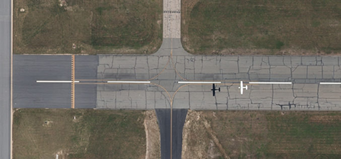
Col-East to Perform Obstacle Obstruction Survey at Massachusetts Airport
NORTH ADAMS, Massachusetts, 10 July 2017 – Col-East International Ltd., a provider of aerial photogrammetric services in the Northeast U.S. since 1952, has been contracted to perform an airborne survey and

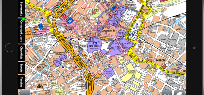
Smart Map Bhopal: A City Level Web-Based GIS solution
Smart Map Bhopal is an enterprise-wide web-based GIS solution created using ArcGIS platform and seamlessly functions across various the web & mobile devices. GIS System will provide
LandScape 7.4: Faster Point Cloud Loading, Change Detection Tools & VR Option
DAT/EM Systems International Updates Landscape Software to Deliver Faster Point Cloud Loading and Change Detection Tools Version 7.4, with Virtual Reality Option, to be Demonstrated at Esri Events in San

CompassCom to Release CompassTracker App for iOS & Windows Mobile Smart Phones at Esri User Conference
CENTENNIAL, Colorado, 6 July 2017 – CompassCom Software, developers of industry-leading Mobile Resource Management (MRM) solutions, will release CompassTracker for iOS and Windows Mobile at the 2017 Esri User Conference.
Emergency Services: Airbox and A-Z Maps Partnership
June 30, 2017 – Geographers’ A-Z Map Company is excited to announce a partnership with Airbox Systems. This partnership will see the inclusion of our map data into world’s leading

Mobile App for Road Maintenance “Aarambh” Launched
PIB – The visiting ILO Deputy Director General (Policy) International Labour Organization Ms. Deborah Greenfield, who is on an official visit to India called on Hon’ble Shri Narendra Singh Tomar,
