
Archive
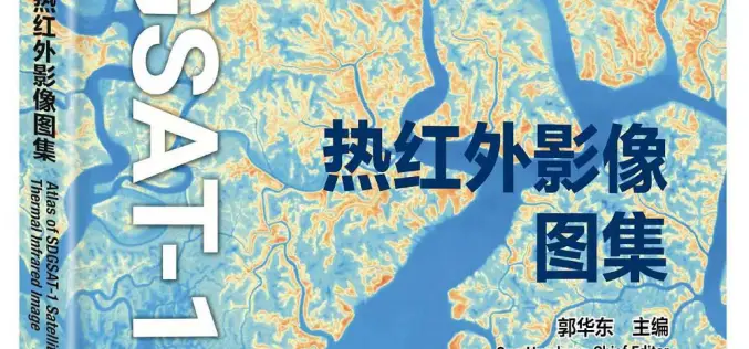
China Unveiled World’s First Thermal Infrared Atlas
China has made a groundbreaking contribution to global sustainability efforts by releasing the world’s first Thermal Infrared Atlas. The atlas was launched during the 4th International Forum on Big Data
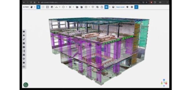
New Reality Capture Platform Service Leverages Trimble Connect to Maximize the Value of Geospatial Data for Millions of Users
Trimble has announced its new Trimble® Reality Capture platform service to enable more effective collaboration and the secure sharing of massive reality capture datasets captured with 3D laser scanning, mobile mapping

Merkator and RMSI Partner to Accelerate Telecom Network Geospatial Transformation
Merkator, a leading provider of next-generation network inventory solutions for telecom operators, today announced a strategic partnership with RMSI UK, a global leader in geospatial solutions and services. This collaboration, via the MarlinDT
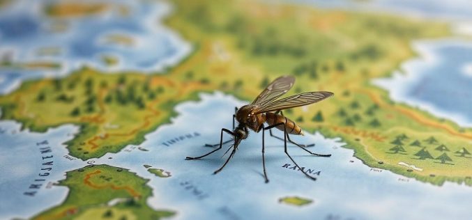
AI Mosquito Mapping in Fighting Mosquito-Borne Diseases
A team of researchers at Heidelberg University has introduced a pioneering AI mosquito mapping technique to track Aedes aegypti populations, the species responsible for spreading diseases like dengue, Zika, chikungunya,
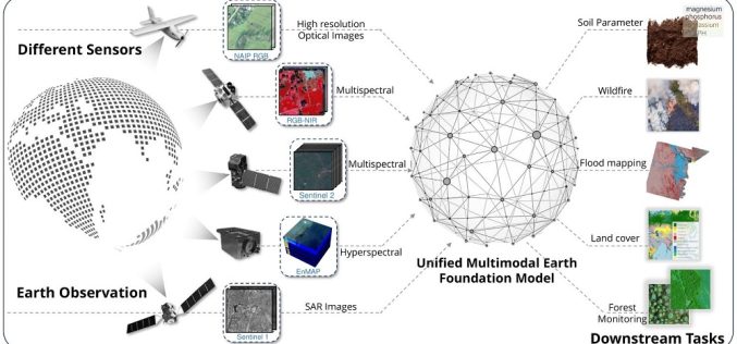
TorchGeo 0.6.0: Advancing Geospatial Machine Learning
TorchGeo 0.6 marks a significant step forward in geospatial machine learning by offering new datasets, data modules, and pre-trained models for satellite image analysis. Over 11 months, 23 contributors worked

Clark Labs to Offer Free TerrSet Geospatial Software
For almost four decades, the TerrSet/IDRISI geospatial software from Clark Labs has played a key role in environmental monitoring, enabling researchers to analyze climate change effects and predict future land
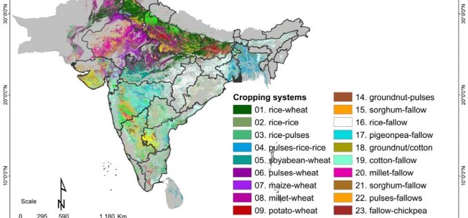
How Geospatial Mapping in Agriculture is Revolutionizing Crop Management Across South Asia By ICRISAT
A recent study by scientists from the International Crops Research Institute for the Semi-Arid Tropics (ICRISAT) has brought to light the pivotal role of geospatial mapping and satellite data in
GeoDiscovery Offers Self-Serve Access to Geospatial Data from AGSL and UWM
The University of Wisconsin-Milwaukee (UWM) has recently unveiled GeoDiscovery, an innovative geoportal developed in collaboration between the American Geographical Society Library (AGSL) and the Digital Collections & Initiatives (DC&I) department.

Space Flight Laboratory (SFL) Selected by NUVIEW to Develop Pathfinder Satellite Bus for Its Space-Based LiDAR Constellation
Space Flight Laboratory (SFL) has been chosen by NUVIEW, a space-technology company specializing in 3D Earth imaging, to develop the bus for Mr. SPoC, its pathfinder small satellite that will

The Role of GIS in Real Estate Valuation and Its Impact on Property Taxes
Property location, geography, and physical attributes have heavily influenced real estate. Traditionally, these factors were assessed manually or through essential technological tools. However, with the advent of Geographic Information Systems
