
Posts From GIS Resources

Spatial Decision Support Systems Principles and Practices
Spatial Decision Support Systems Principles and Practices Ramanathan Sugumaran John DeGroote Spatial decision support systems (SDSS) are designed to help decision makers solve complex spatially related problems and provide a

Back to Back Three Satellite Launches by Iran Next Year
The Zafar, Tolou and AutSat are the three Iranian remote sensing satellites are line up to launch using Simorgh Launcher in the coming year (to start March 21, 2015). These
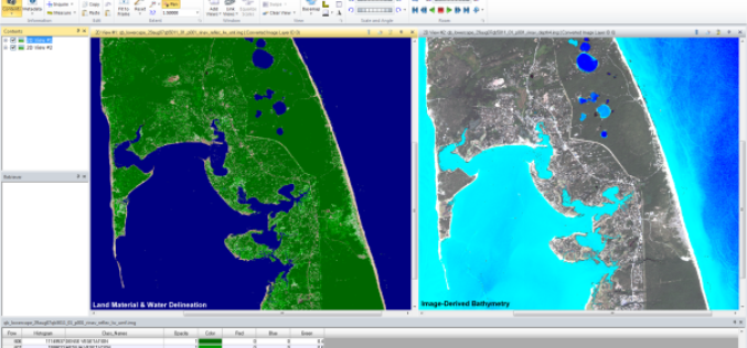
Hexagon Geospatial Enhances ERDAS IMAGINE 2014
New Service Pack Enhances Workflows, and Supports New Formats and Sensor Models NORCROSS, Ga., May 30, 2014 – Hexagon Geospatial announces the release of a new service pack for ERDAS

PR: New Esri Book Inspired by Classic Flow Map of Napoleon’s Russian Campaign
Mapping Time Examines Challenges of Temporal Mapping Redlands, California—Published by Esri Press, Menno-Jan Kraak’s book Mapping Time: Illustrated by Minard’s Map of Napoleon’s Russian Campaign of 1812 combines historical and geographic analysis with

SDMC & GeoSpatial Delhi Signed a MoU to provide UPIC
In recent news, South Delhi Municipal Corporation (SDMC) and GeoSpatial Delhi has signed a Memorandum of Understanding (MoU) to give Unique Property Identification Code (UPIC) to all properties in the
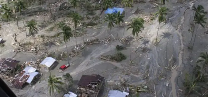
Philippines Government to do 3D Mapping in Disaster Mitigation
In recent news, as a part of the Disaster Risk Assessment, Exposure and Mitigation – Light Ranging and Detection Technology (DREAM-LiDAR) project, a collaboration between Department of Science and Technology
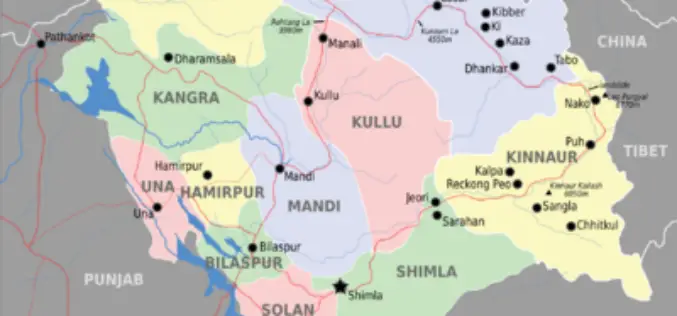
Glaciers and Lakes Mapping in Himachal Pradesh
In recent new, Scientists are mapping the glaciers and lakes in Himachal Pradesh keeping in mind the climate vulnerability and hazards. State Centre for Climate Change will map all glaciers

Highway App by West Bengal Highway Development Corporation
In recent news, tourists in West Bengal will get all the information they need on state highways at the touch of a button, courtesy a mobile phone app that informs

PR: New York State Police Implement GeoComm Mapping in New Call Center
The New York State Police (NYSP) recently worked with GeoComm to implement a new tactical 9-1-1 mapping system. GeoLynx Server was installed at the new Troop G Communications Center in
Webinar: Streamlining Field Survey & Mobile Mapping by SuperSurv
Supergeo Webinar: Streamlining Field Survey & Mobile Mapping by SuperSurv Join us on Wednesday, June 4th 11:00 AM – 12:00 PM (EDT, New York Time) How could smart devices assist in field survey
