New Service Pack Enhances Workflows, and Supports New Formats and Sensor Models
ERDAS IMAGINE 2014
NORCROSS, Ga., May 30, 2014 – Hexagon Geospatial announces the release of a new service pack for ERDAS IMAGINE 14.0, which includes several new formats and sensor models.
The new HDF-EOS-5 format provides access to data widely used in natural sciences. The service pack also offers format compliance for GeoEye data and there are new read/write capabilities for LASzip, an open source LiDAR compression from rapidlasso.
“We are always looking for new ways to enhance the usability of ERDAS IMAGINE to help support the next-generation needs of our growing user base,” said Mladen Stojic, President of Hexagon Geospatial. “These updates include new methods for streamlining workflows in ways that continually help our users best drive enhanced decision-making for their organizations.”
Hexagon Geospatial is also offering solutions to enhance and streamline the workflow for Image Analysts. This includes enhancements to the Inquire Cursor, long name support in NITF metadata, extended options for ‘Send to JPEG’ and other Send to Office tools, as well as the ability to easily copy/paste graphics to Map compositions.
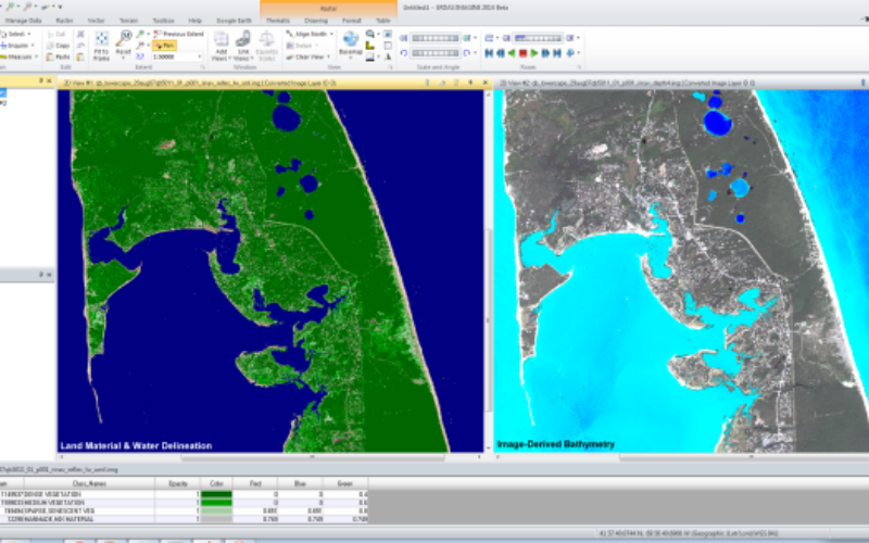
In addition, Hexagon Geospatial’s partner Applied Analysis Inc. contributed IMAGINE RINAVTM for U.S. Government customers and another new add-on called IMAGINE GeoPaletteTM . These products complement IMAGINE AAIC, which was introduced with ERDAS IMAGINE 2014. Users can apply standardized feature classification algorithms to a wide array of image types, producing information products such as Land Material Identification, Bottom Material Identification and Water Clarity – with little user expertise required.
For more information about ERDAS IMAGINE, please visit www.hexagongeospatial.com/imagine.
About Hexagon Geospatial
Hexagon Geospatial helps you make sense of the dynamically changing world. Hexagon Geospatial provides the software products and platforms to a large variety of customers through direct sales, channel partners, and Hexagon businesses, including the underlying geospatial technology to drive Intergraph Security, Government & Infrastructure (SG&I) industry solutions. Hexagon Geospatial is a division of Intergraph Corporation. For more information, visit www.hexagongeospatial.com.
For Further Information:
Jason Sims
Executive Director of Content & Campaign Management
Jason.Sims@hexagongeospatial.com