
Featured Article

Strengthening GNSS Resilience: Trimble Leadership on IonoGuard Innovation and Solar Cycle 25
As the effects of Solar Cycle 2025 intensify, industries dependent on precise positioning—such as surveying, agriculture, construction, and autonomous systems—are facing growing challenges due to ionospheric disturbances. In response to
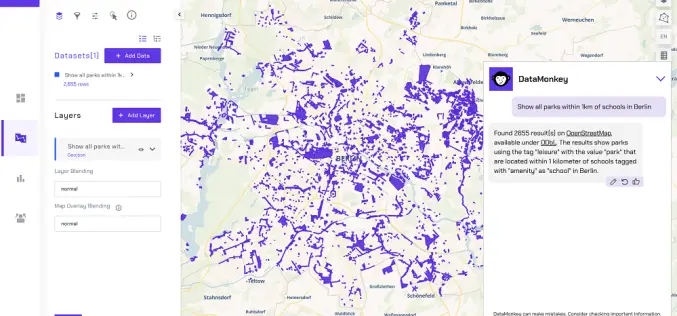
Finding the Map in the Mess: Making Geospatial Data Easy
About Authors: Irene Ternes & Engy El Shenawy, DataMonkey Whether we notice it or not, our world is shaped by location data. From climate risk and infrastructure planning to supply
Beyond the Map: What the GIS Stack Looks Like in 2025
About Author Subhankar Naskar Team Lead, Geospatial Technology, iMerit He’s a geospatial professional blending AI with GIS to predict the future—literally. He holds a B.Sc. in Geography, an M.Sc. in

Hyperspectral Plastic Detection for Riverine Cleanup
Plastic pollution in rivers is a growing environmental challenge. With millions of tons of plastic waste flowing into oceans annually, the need for effective monitoring and cleanup has never been
From imagery to impact: how high-resolution aerial data transformed water sustainability efforts in Southern California
Authored by- Hexagon In Southern California, water scarcity is a critical issue. Due to periodic droughts and the growing impacts of climate change, the region faces urgent challenges when it
IBM and NASA Launch Prithvi-EO-2.0 for Advanced Geospatial Analytics
In collaboration with NASA, IBM has launched the Prithvi-EO-2.0 Platform, a groundbreaking geospatial AI tool designed to tackle critical environmental, social, and economic challenges. With its cutting-edge technology, extensive datasets,
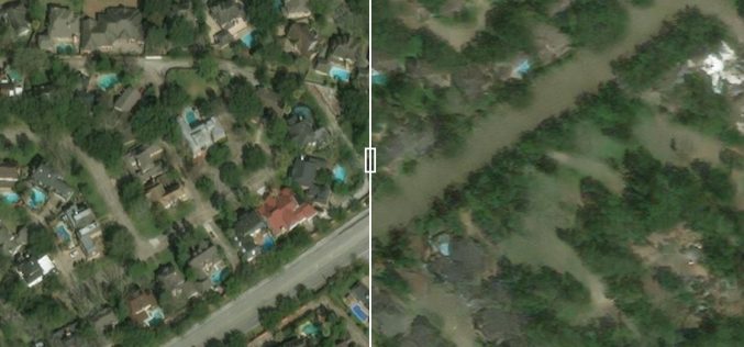
Predicting Flood Impacts with Generative AI and Physics-Based Models
Understanding the potential effects of hurricanes before they strike is crucial for helping residents prepare and take necessary actions, such as evacuation. Researchers at MIT have developed an innovative approach

LiDAR Technology Uncovers Hidden Silk Road Cities in Uzbekistan
Recent advancements in LiDAR (Light Detection and Ranging) technology have revealed hidden remnants of Silk Road cities in Uzbekistan, uncovering archaeological treasures that had remained buried for centuries. The discovery

Taiwan Uses Satellites for Banana Disease Detection
The Taiwan Space Agency (TASA) is utilizing advanced satellite-based banana disease detection to address a critical issue in agriculture—detecting and managing the devastating Fusarium Tropical Race 4 (TR4) disease in
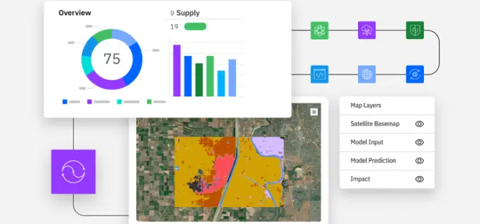
Exploring the Power of IBM Environmental Intelligence APIs for Geospatial Insights
The IBM Environmental Intelligence APIs are designed to equip data scientists and developers with high-quality environmental data sets. These APIs offer a comprehensive set of geospatial, climate, and weather data,
