
GIS

OpenStreetMap for Emergency Response
This past week was intense – the most powerful hurricane ever recorded in the Western Hemisphere made landfall, just missing major population centers and avoiding catastrophic damage. Three days later,

Tell Your Story to Airbus Defence and Space and Win €500 GeoStore Voucher
Are you using Airbus Defence and Space products and solutions for sectors such as Defence and Intelligence, Oil & Gas, Emergency Response, Land Administration, Civil Engineering, Forestry & Environment, Agriculture
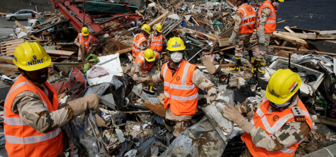
NDRF Joins Hands with ISRO to Get Real-time Satellite Data for Disaster Rescue
In a bid to obtain the vital “third eye” to tackle disasters, the National Disaster Response Force (NDRF) has inked a pact with the National Remote Sensing Centre (NRSC) which

A Drone with a Sense of Building Its Own Maps
MIT Technology Review – Researchers from the Swiss Federal Institute of Technology in Zurich are making drones more independent with a sense of building its own direction. They have demonstrated

India Proposes Use of Geospatial Technologies to Strengthening Mutual Cooperation between BRICS Nations
The Minister for Science, Technology and Earth Sciences, Dr. Harsh Vardhan is leading an Indian delegation to the 3rd BRICS Ministerial Meeting on Science, Technology and Innovation (STI) being held
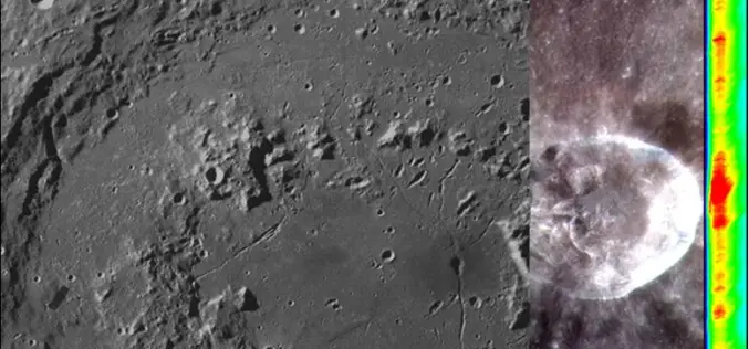
Opportunity for Utilizing Chandrayaan-1 Data from Terrain Mapping Camera and Hyperspectral Imager
Space Applications Centre (SAC), Indian Space Research Organisation (ISRO), Department of Space (DOS), Government of India, declares an “Announcement of Opportunity (AO)” to carry out scientific research by utilisation of
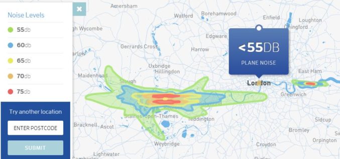
Map Aircraft Noise Pollution Where You Live
Club Med has launched a tool to map noise pollution information from Department for the Environment, Food & Rural Affairs (Defra), UK to map the decibel level from aircrafts. The

Nigeria to Use Drones to Fight Insecurity and Insurgency
According to recent news, Surveyors of the Nigerian Institution of Surveyors (NIS) and seasoned security experts, including Ade Abolurin, retired commandant-general; Nigeria Security and Civil Defence Corps have given advice to

3D Maps of Buildings to Improve Disaster Management Plans
India – In order to improve disaster management plans, the Gurgaon administration has decided to prepare 3D maps of 100 buildings in the city, including office complexes and hospitals. Gurgaon
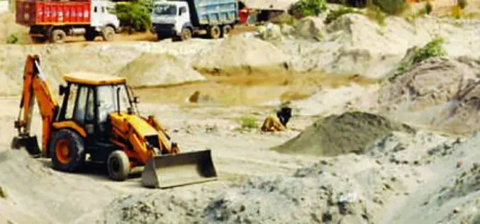
Geospatial Mapping to Curb Illegal Sand Extraction
India – The Goa State Expert Appraisal Committee (GSEAC) has issued instructions to the District Collectors to carry out survey and mapping of sand extraction lease boundaries through Global Positioning
