
GIS

TomTom Revolutionises the Way Maps Are Delivered
MultiNet-R enables customers to deliver maps to the market faster and easier Amsterdam, 12 November 2014 – TomTom (TOM2) today announces the availability of MultiNet-R, a new and innovative
Gartner Names GE a Leader in “Magic Quadrant” Report for Utilities Geographic Information Systems
Digital Energy business today announced that it has been named as one of the industry’s leading solutions provider of Utilities Geographic Information Systems software. This was announced in a recent

Environment Ministry Launches GIS Based Online Support Mechanism
Aimed at bringing transparency and reduce delays in regulatory clearances, the environment ministry today launched the Geographical Information System (GIS) based online support mechanism to help in taking

Exprodat Supports Geothermal Resource Exploration at Utah State University
Exprodat, the oil and gas GIS services, software and training supplier has provided the Geology Department at Utah State University (College of Science) with licenses of their popular Exploration Analyst and Data Assistant extensions to Esri’s
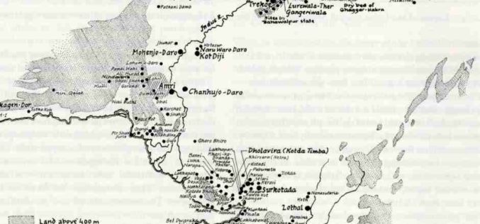
Geo-coordinates of 700 Harappan Sites in Gujarat to be updated in Maharaja Sayajirao University’s Gazette
An illustrated Gazetteer on 700 Harappan and affiliated Chalcolithic sites spread across Gujarat, which were surveyed using the GIS (Geographical Information System) to update the geo coordinates of these early
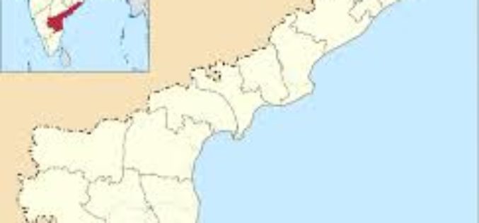
Andhra Pradesh to Initiate HARITA Initiative for Better Planning
Andhra Pradesh government plans to initiate another high-tech initiative called Harmonised Information of Agriculture, Revenue and Irrigation for a Transformation Agenda (HARITA). The initiative aims at creating an information highway in
NGA Announces CIA Veteran as Deputy Director
SPRINGFIELD, Virginia — The National Geospatial-Intelligence Agency announced today that Susan M. Gordon, a 34-year veteran of the intelligence community, will become deputy director upon the retirement of Mike Rodrigue,

Esri Advances Scientific Analysis with SciPy
ArcGIS Programming Library Adds Power to Problem-Solving Redlands, California—Esri announces the integration of SciPy and ArcGIS. Scientists, engineers, and GIS professionals will use SciPy to get more value from ArcGIS
Malaysia to Use Geospatial Technology to Strengthen Defence
In recent news, Malaysia’s research agency (Malaysian Institute of Microelectronics Systems – MIMOS) has signed an agreement with Esri to enhance the government’s research efforts in knowledge sharing as well

3D Laser Mapping Helps Preserve Earthquake Prone Buildings in New Zealand
New Zealand based Solutions By Zeal is reaping the rewards of using the ZEB1 hand held laser mapping system to survey buildings at risk from earthquakes or in need of
