
GIS
Supergeo Extends Free SuperGIS Desktop License Policy for Students
Supergeo Technologies, the leading GIS software provider, announced the extended policy of free SuperGIS Desktop 3.2 license for students. The universities, colleges and high schools that purchase SuperGIS Desktop Lab

ThinkGeo Releases Map Suite for Android, iOS and WebAPI
Frisco, TX — ThinkGeo is proud to announce the additions of Map Suite WebAPI , Map Suite for Android and iOS platforms to the Map Suite family of products. These

HERE Launches Predictive Traffic
Charlotte, N.C. – HERE, a leader in navigation, mapping and location experiences, today launched Predictive Traffic, a new traffic forecasting product that can anticipate future traffic conditions in real-time. HERE

LizardTech to Demonstrate a UAV Workflow at the Esri Southwest User Conference
SEATTLE, Wash. – LizardTech®, a provider of software solutions for managing and distributing geospatial content, will give a UAV oriented presentation at the Esri Southwest User Conference in Sante Fe,

Free Digital Mapping Service for Colleges by Ordnance Survey
Today Ordnance Survey and Jisc – the charity that offers digital services and solutions to UK education and research – are set to release Digimap for Colleges. The secure, free and easy to use
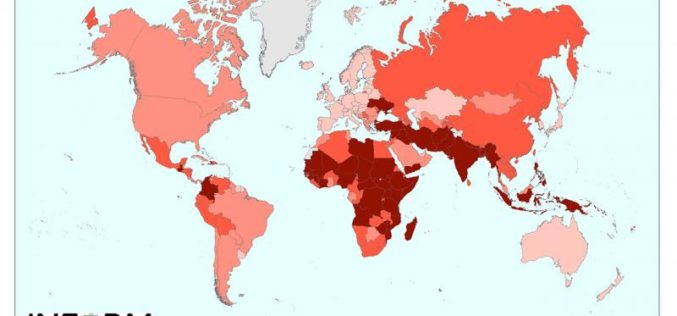
New Tool for Understanding the Risk of Humanitarian Crises and Disasters
The first global open-source risk assessment tool for humanitarian crises and disasters was launched today.INFORM (Index for Risk Management) is designed to support decisions about prevention, preparedness and response, helping humanitarian
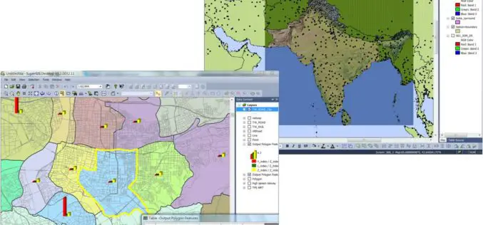
SuperGIS is Selected for Public Infrastructure in Nepal
Supergeo Technologies, the global leading GIS software and solution provider, announces that Rajdevi Engineering Consultant utilizes SuperGIS Desktop, SuperGIS Spatial Analyst and SuperGIS 3D Analyst in several governmental public infrastructure

Geospatial Technology for National Planning
In recent news, Kenya is planning to use geospatial technology in its national planning process to facilitate governance. Cabinet Secretary in the Ministry of Devolution and Planning Anne Waiguru told

USGS-NASA Award Recognizes Innovations in Earth Observation
A pioneer in mapping global land cover change and the team behind the United States’ most advanced land surface mapping satellite have both been honored with the 2014 William T. Pecora

Vietnam Completes Spatial Database of Entire Territory
According to news published in Vietnamnet, Vietnam has completed the spatial database of country’s entire territorial waters, including Hoang Sa (Paracel) and Truong Sa (Spratly) archipelagos. The database have multi-temporal satellite
