
Remote Sensing
Remote Sensing to Study Dynamics of Cropland in Latin America
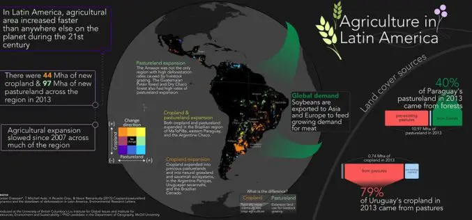
In a study, “Cropland/pastureland dynamics and the slowdown of deforestation in Latin America,” published in Environmental Research Letters by Jordan Graesser and et. al., brings out some interesting facts about
Taiwan has Indigenously Built its First Optical Remote Sensing Instrument for FORMOSAT-5 Satellite
In recent news from Focus Taiwan, the National Applied Research Laboratories (NARLabs) of Taiwan, announced that country has indigenously built the first optical remote sensing instrument (RSI) in Taiwan that
A Case Study: Using Drones in Place of LiDAR
Energizer Resources Inc., has started a major flagship project, a large graphite mining project at coast of East Africa, in Madagascar. it is named the Molo Graphite Project, or simply
Drone to Spread Beneficial Bugs on Crop
University of Queensland agricultural science student Michael Godfrey has developed a drone that spreads beneficial insects onto crops, potentially saving farmers time and money. During his Summer Science Scholarship, Mr
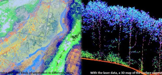
Protecting Nature Using Airborne Laser Footprint Data
In a study by Prof. Norbert Pfeifer at the Vienna University of Technology, reveals the significance of using airborne laser technology in protecting nature. The study area is ‘‘Nagyerdo˝’’ (Great
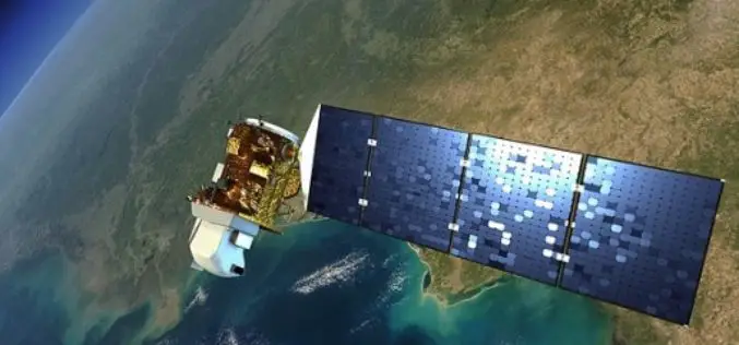
Landsat 9 to Continue Land Imaging Legacy of the U.S. Space Program
In recent news update by NASA, NASA and USGS are working together on Landsat 9, schedule to launch in 2023. NASA will build, launch, perform the initial check-out and commissioning
Over 20 Concepts For Applied Projects In “Remote Sensing Applications Competition” Launched By EIAST
The competition aims to develop mechanisms and programs that serve various governmental sectors As part of the Remote Sensing Applications Competition 2014, launched by the Emirates Institution for Advanced Science
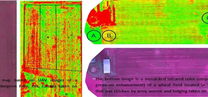
Applications of Low Altitude Remote Sensing in Agriculture
In a study by Chunhua Zhang et. al., on “Applications of Low Altitude Remote Sensing in Agriculture upon Farmers’ Requests– A Case Study in Northeastern Ontario, Canada” reveals the importance

World’s Biggest Aerial LiDAR Survey to Reveal Angkor Wat Historical Secrets
Angkor, in Cambodia’s Northern Province of Siem Reap, is one of the most important archaeological sites of Southeast Asia and listed in world heritage sites by UNESCO. Stretching over some

Tribal Ministry to Use Satellite Mapping to Develop Water Bodies
The Ministry of Tribal Affairs (MoTA) is planning to use satellite mapping to identify potential water collection spots, which could be developed for fish culture and other purposes in order
