Using Landsat Vegetation Indices to Estimate Impervious Surface Fractions for European Cities
Using Landsat Vegetation Indices to Estimate Impervious Surface Fractions for European Cities
– Kaspersen, P.S.; Fensholt, R.; Drews, M. Using Landsat Vegetation Indices to Estimate Impervious Surface Fractions for European Cities. Remote Sens. 2015, 7, 8224-8249.
Abstract:
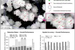
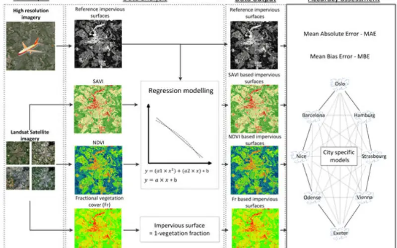
Impervious surfaces (IS) are a key indicator of environmental quality, and mapping of urban IS is important for a wide range of applications including hydrological modelling, water management, urban and environmental planning and urban climate studies. This paper addresses the accuracy and applicability of vegetation indices (VI), from Landsat imagery, to estimate IS fractions for European cities. The accuracy of three different measures of vegetation cover is examined for eight urban areas at different locations in Europe.

The Normalized Difference Vegetation Index (NDVI) and Soil Adjusted Vegetation Index (SAVI) are converted to IS fractions using a regression modelling approach. Also, NDVI is used to estimate fractional vegetation cover (FR), and consequently IS fractions. All three indices provide fairly accurate estimates (MAEs ≈ 10%, MBE’s < 2%) of sub-pixel imperviousness, and are found to be applicable for cities with dissimilar climatic and vegetative conditions. The VI/IS relationship across cities is examined by quantifying the MAEs and MBEs between all combinations of models and urban areas. Also, regional regression models are developed by compiling data from multiple cities to examine the potential for developing and applying a single regression model to estimate IS fractions for numerous urban areas without reducing the accuracy considerably. Our findings indicate that the models can be applied broadly for multiple urban areas, and that the accuracy is reduced only marginally by applying the regional models. SAVI is identified as a superior index for the development of regional quantification models. The findings of this study highlight that IS fractions, and spatiotemporal changes herein, can be mapped by use of simple regression models based on VIs from remote sensors, and that the method presented enables simple, accurate and resource efficient quantification of IS.
Keywords: impervious surfaces, remote sensing, Landsat, Europe, NDVI, SAVI, fractional vegetation cover, regression modelling,urban land cover change