
Research Papers
Comparing Machine Learning Classifiers for Object-Based Land Cover Classification Using Very High Resolution Imagery
Comparing Machine Learning Classifiers for Object-Based Land Cover Classification Using Very High Resolution Imagery – Yuguo Qian, Weiqi Zhou , Jingli Yan, Weifeng Li and Lijian Han Abstract: This
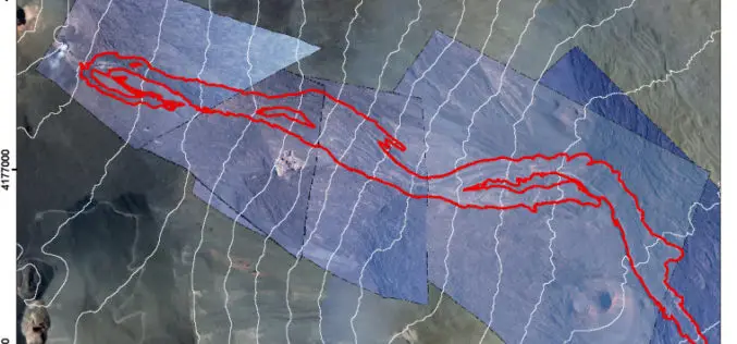
Monitoring Active Volcanoes Using Aerial Images and the Orthoview Tool
Monitoring Active Volcanoes Using Aerial Images and the Orthoview Tool – Maria Marsella, Carla Nardinocchi, Cristina Proietti, Leonardo Daga and Mauro Coltelli Abstract: In volcanic areas, where it can be difficult to
High-Resolution Land Surface Modeling Utilizing Remote Sensing Parameters and the Noah UCM: A Case Study in the Los Angeles Basin
High-Resolution Land Surface Modeling Utilizing Remote Sensing Parameters and the Noah UCM: A Case Study in the Los Angeles Basin – P. Vahmani and T. S. Hogue Abstract: In the
Can Night-time Light Images Play a Role in Evaluating the Syrian Crisis?
Can night-time light images play a role in evaluating the Syrian Crisis? Xi Lia & Deren Lia a; State Key Laboratory of Information Engineering in Surveying,Mapping and Remote Sensing, Wuhan University, Wuhan 430079,China

Two Publications on How to Best use Remote Sensing Data at a 1-km scale
The NCEAS Environment and Organisms Working Group set about to assemble a state-of-the-art set of environmental layers that incorporate well-known but rarely used measures that have direct links to
Remote Sensing Data for Managing Climate Risks: Index-based Insurance and Growth related Applications for Smallhold-farmers in Ethiopia
Remote Sensing Data for Managing Climate Risks: Index-based Insurance and Growth related Applications for Smallhold-farmers in Ethiopia Stefan Hochrainer-Stigler, Marijn van der Velde , Steffen Fritz , Georg Pflug Abstract: The aim of
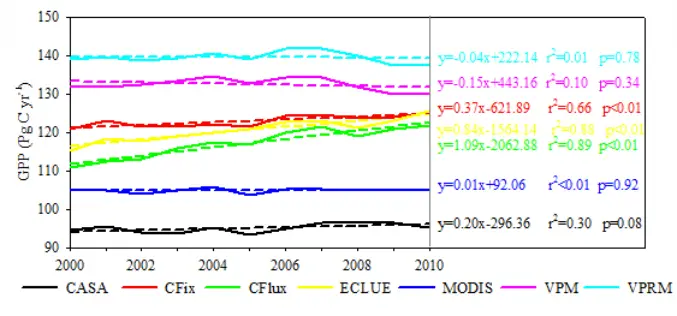
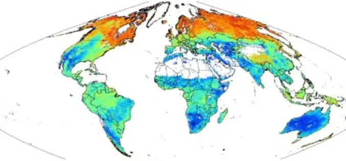
Large Differences in Terrestrial Vegetation Production Derived from Satellite-Based Light Use Efficiency Models
Large Differences in Terrestrial Vegetation Production Derived from Satellite-Based Light Use Efficiency Models Wenwen Cai , Wenping Yuan, Shunlin Liang, Shuguang Liu, Wenjie Dong, Yang Chen, Dan Liu, and Haicheng Zhang Abstract: Terrestrial gross primary production (GPP) is the
SoilGrids1km — Global Soil Information Based on Automated Mapping
SoilGrids1km — Global Soil Information Based on Automated Mapping By- Tomislav Hengl, Jorge Mendes de Jesus, Robert A. MacMillan, Niels H. Batjes, Gerard B. M. Heuvelink, Eloi Ribeiro, Alessandro Samuel-Rosa, Bas
Geospatial Analysis of Biomass in Lake Region of Kumaun Himalaya, Uttarakhand
Abstract The present study includes vegetation and forest biomass mapping in the lake region of Kumaun, Uttarakhand, using IRS1C LISSIII satellite data. A total of 11 forest types including forest
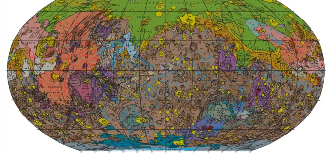
Geologic Map of Mars
Geologic Map of Mars Abstract This global geologic map of Mars, which records the distribution of geologic units and landforms on the planet’s surface through time, is based on unprecedented
