
Software

TatukGIS Releases 64 Bit Version of Free GIS Viewer
TatukGIS announces release of the 64 bit version of its popular free desktop GIS Viewer. Now the free Viewer, like its more powerful sibling the TatukGIS Editor, is available as

AutoTrace Plugin for QGIS
AutoTrace is a plugin for QGIS that allows you to trace existing features. The AutoTrace plugin is based on the traceDigitize plugin by Cédric Möri and others. Installation AutoTrace is available from the

Introducing Geocortex Essentials 4.0
This introduction comes from Geocortex Blog by Latitude Geographics written by Drew Millen on Feb. 05, 2014 … After eighteen months of infrastructure development, we have reached an important milestone in

Navitel Navigator Releases Q1 2014 Update of Maps of Europe, Central Asia, Russia and Turkey
Q1 2014 update of NAVITEL® maps of Europe, Central Asia, Russia and Turkey announced! The users of Navitel Navigator can update maps of Europe, Central Asia, Russia and Turkey up to the Q1 2014 version. The Q1 2014
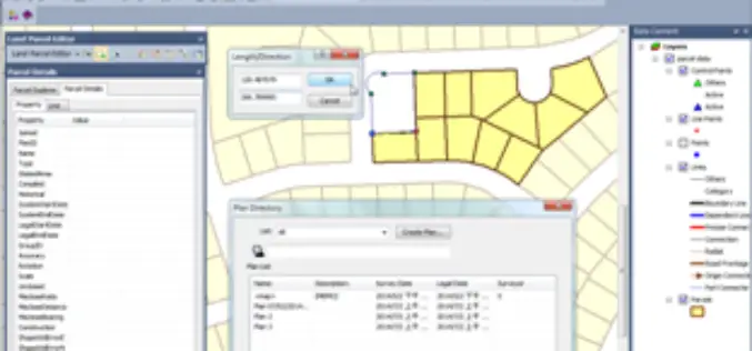
PR: Land Parcel Editor in SuperGIS Desktop Allows to Manage Parcel Data with Ease
Supergeo Technologies, a leading global provider of complete GIS software and solutions, announced that SuperGIS Desktop 3.2, the newest desktop GIS software, supports Land Parcel Editor to assisting users in

Dubai to Implement 10-digit code for Geocoding
Municipality of Dubai is planning to launch a unique digital address system ‘Makani’ to find out any location in Dubai. An application called Makani supporting the Dubai grid addressing scheme has

Online Vector and Raster Converter Tool
MyGeodata Converter is an online tool that allows you to read and write from/to a huge number of CAD and GIS formats – both vector and raster. In contrast to
TatukGIS Developer Kernel for ASP.NET
TatukGIS announces release of the Developer Kernel for ASP.NET (DK.ASPNET) edition for custom GIS web server development. The DK for ASP.NET is a pure .NET SDK supporting HTML5/JavaScript technology for

Apple’s 3D recording concept could allow user-generated ‘street views’ in Maps
On Tuesday, The U.S. Patent and Trademark Office awarded Three-Dimensional Model Using a Portable Electronic Device Recording, to Apple. Apple Insider first detailed the patent, when it was simply a

ADC WorldMap Releases Digital Atlas Version 7.0
ADC WorldMap, a leader in providing comprehensive, current, and seamless geographic digital data for the whole Earth, is pleased to announce the release of ADC WorldMap Digital Atlas v7.0.
