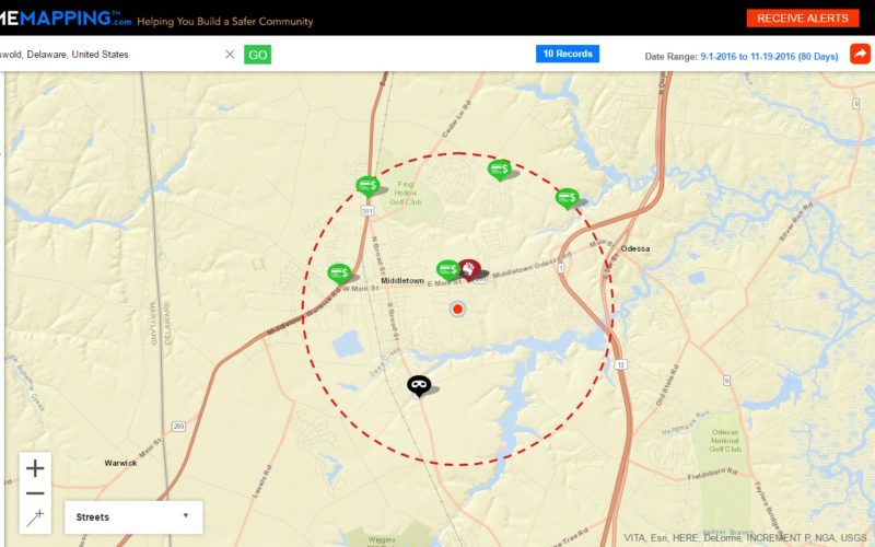
Delaware, USA Nov. 17, 2016 – Crime mapping is one tool that serves that purpose and is an extraordinary example of Delaware State Police (DSP) effort to leverage technology to improve services to better inform the public. A mutual benefit where residents are better informed and encouraged to be vigilant is a win, win. Like a virtual neighborhood, it is an opportunity to lend a hand for community members who want to see what is going on locally in their own community. It helps to reduce misinformation when people have real time data and facts. Mapping data can also act as a deterrent to crime and serve as a safety measure in community policing to make people more engaged, aware and cautious.
The Delaware State Police is providing access to this website which makes crime information available to the public. The mapping service allows residents to analyze interactive maps of recent crime activity near their neighborhoods, workplaces, schools and places of interest.
The Delaware State Police will update crime data and log it into the Crime Mapping website every 24 hours and is available for up to 180 days past the date the crime occurred, so essentially the public will have the ability to receive personal crime alerts within the 180 days of rolling data and will be able to submit crime tips to the Delaware State Police from this platform.
The website can be accessed by going to the official Delaware State Police website http://dsp.delaware.gov/ .
The goals are to keep the public informed of crimes that may affect them and to allow the community to assist in the crime reduction process for a safer Delaware.
Source: Delaware State Police (DSP)


